
Scattered Strong to Severe Storms With Damaging Wind Gusts From Downbursts Possible Across North Carolina This Sunday Afternoon and Evening as Cooler Front Arrives Tonight
NORTH CAROLINA — A hot and humid Sunday across North Carolina is setting the stage for scattered strong to severe thunderstorms this afternoon and evening, with a cold front moving through tonight that will usher in slightly cooler air for the start of the week. High CAPE values combined with sufficient wind shear mean a couple of storms today could become strong to severe, with damaging wind gusts from downbursts identified as the main threat.
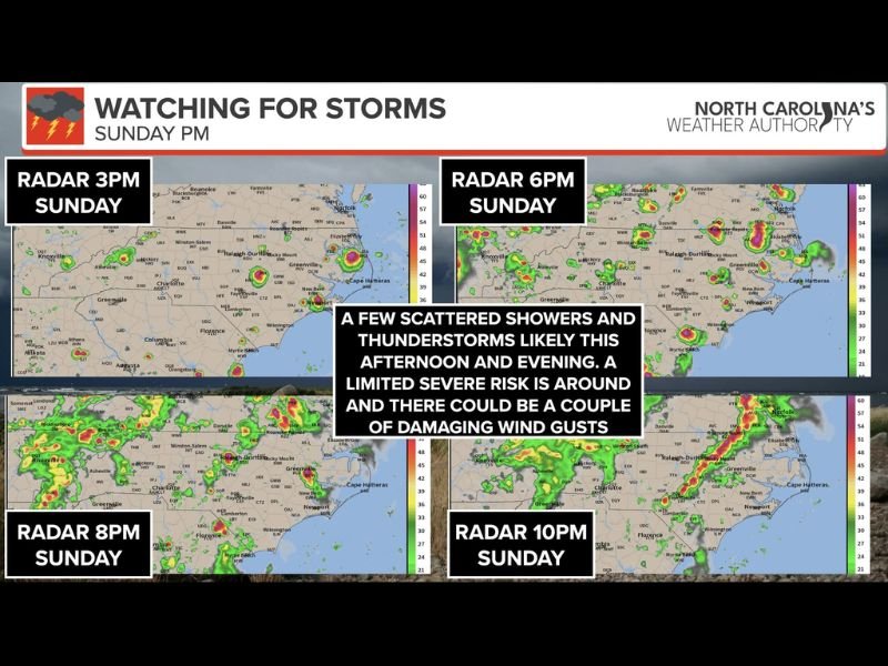
Hit-or-Miss Storm Coverage Means Not Everyone Sees Severe Weather
Storm coverage today will be very scattered and hit-or-miss in nature, developing mainly in clusters ahead of the approaching front. While not everyone across the state will see a storm, the radar sequence from 3 PM through 10 PM Sunday shows multiple rounds of activity tracking across the state through the afternoon and evening hours.
Severe weather can vary significantly over short distances today, meaning one neighborhood could see a damaging downburst while another nearby location sees nothing at all.
Damaging Wind Gusts From Downbursts Are the Primary Threat
The main hazard today is damaging straight-line winds produced by downbursts — powerful, localized columns of sinking air within a thunderstorm that plummet to the ground and spread out in all directions. These can create destructive wind gusts capable of downing trees and causing power outages even from storms that may not look particularly intense on radar.
The radar progression through 8 PM and 10 PM shows storm activity becoming more numerous and organized across the state as the evening progresses and the front approaches.
Cold Front Tonight Brings Slightly Cooler Air for Monday
A cold front moving through North Carolina tonight will bring an end to today’s storm threat while ushering in slightly cooler air for the beginning of the workweek. Anyone with outdoor plans this afternoon or evening should have multiple ways to receive weather alerts and a pre-planned secure location ready in case conditions deteriorate quickly. Stay with NapervilleLocal.com for the latest weather updates and local forecast coverage.

I’ve lived in Naperville long enough to see how quickly our community changes — from new developments downtown to sudden shifts in our Midwest weather. Reporting on Naperville news and daily forecasts gives me the chance to keep neighbors informed about what really matters. My goal is simple: deliver clear, timely updates so you always know what’s happening in our city and what to expect from the skies above.