
Tornadoes, Large Hail, and Damaging Winds Threaten Missouri and the Mid-Mississippi Valley Including Kansas City and St. Louis Under Day 4 Enhanced Risk for Wednesday
MISSOURI/MID-MISSISSIPPI VALLEY — Forecasters are monitoring a Day 4 Enhanced Risk for severe weather on Wednesday, June 17, with all types of severe weather possible including tornadoes, damaging winds, and large hail. The highest threat is centered across Missouri and the Mid-Mississippi Valley, where some storms could become particularly dangerous. The severe weather threat may extend into the overnight hours across parts of the Ohio Valley as conditions remain favorable for strong to severe thunderstorms after dark.
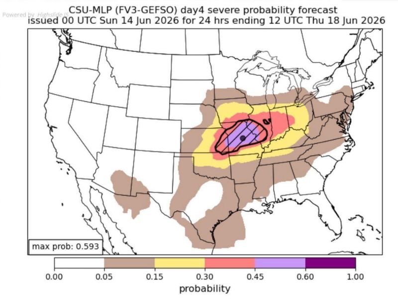
Missouri and Mid-Mississippi Valley Core Faces Highest Probability
The outlook map shows a probability gradient with the highest values, shown in purple, centered directly over Missouri and extending into the Mid-Mississippi Valley, with a max probability of 0.593. This core zone includes Kansas City, Columbia, Jefferson City, St. Louis, Joplin, Springfield, and Cape Girardeau, all falling within the highest-probability region for significant severe weather Wednesday.
A red zone with 0.30 to 0.45 probability surrounds this core, extending into southern Illinois and western Kentucky, including Quincy, Springfield Illinois, Effingham, and Carbondale.
Broader Yellow Zone Extends Across the Ohio Valley and Beyond
A broader yellow zone carrying 0.15 to 0.30 probability stretches across a wide area including Chicago, Rockford, Peoria, Champaign, and the broader Illinois corridor, as well as extending eastward toward the Ohio Valley. The brown outer zone with 0.05 to 0.15 probability extends across an even larger footprint covering portions of the Plains, Midwest, and Southeast.
This widespread coverage area reflects the significant uncertainty still present four days out, but the overall signal supports a substantial severe weather event.
Overnight Threat Possible Across the Ohio Valley
A notable concern with Wednesday’s setup is that the severe weather threat may not end at sunset. Conditions across parts of the Ohio Valley are expected to remain favorable for strong to severe thunderstorms after dark, extending the window of concern into the overnight hours.
Residents across Missouri, Illinois, and the broader Mid-Mississippi and Ohio Valley regions should monitor forecast updates closely as Wednesday approaches. Stay with NapervilleLocal.com for the latest weather updates and local forecast coverage.

I’ve lived in Naperville long enough to see how quickly our community changes — from new developments downtown to sudden shifts in our Midwest weather. Reporting on Naperville news and daily forecasts gives me the chance to keep neighbors informed about what really matters. My goal is simple: deliver clear, timely updates so you always know what’s happening in our city and what to expect from the skies above.