
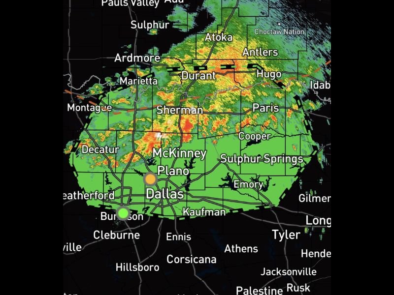
Localized Flash Flooding Possible With 2 to 3 Inches of Rain in a Short Time Across Dallas, McKinney, Sherman, and Durant as Decaying Storm Complex
TEXAS/OKLAHOMA — A decaying complex of thunderstorms is moving through North Texas and southern Oklahoma and beginning to align with favorable upper-level winds, a setup that can cause storms to repeatedly track over the same areas. This training pattern is leading to periods of moderate to heavy rainfall across the Dallas metro and surrounding communities, with rainfall rates capable of quickly producing 2 to 3 inches of rain in a short amount of time.
Dallas-Fort Worth Metro Seeing Heavy Rain Bands Move Through
The radar shows an extensive complex of storms with embedded heavy cores stretching across the Dallas-Fort Worth metro area, including McKinney, Plano, Burleson, and Cleburne. The alignment of this complex with the upper-level wind flow means individual cells can move repeatedly over the same neighborhoods, dramatically increasing localized rainfall totals even in areas that may not see the heaviest core directly.
Residents in the Dallas metro should avoid driving through water-covered roads, as conditions on roadways can change rapidly as rainfall rates increase.
Sherman, Durant, and the Texoma Region Also in the Path
To the north, the storm complex extends through Sherman, Durant, Hugo, and Antlers along the Texas-Oklahoma border, with heavy rain cores visible across this corridor as well. Paris, Cooper, and Sulphur Springs to the east are also within the broader area experiencing rounds of moderate to heavy rainfall.
This entire corridor faces the same training storm risk, where repeated rounds of rain over the same locations can lead to rapid and significant rainfall accumulation.
Watch for Rapidly Changing Conditions on Roadways
With rainfall rates capable of producing 2 to 3 inches quickly, conditions on area roadways can deteriorate within minutes. Never attempt to drive through flooded roadways, even ones that appear shallow, as water depth and current strength can be deceiving.
Residents across North Texas and southern Oklahoma should monitor local alerts closely as this complex continues to track through the region. Stay with NapervilleLocal.com for the latest weather updates and local forecast coverage.

I’ve lived in Naperville long enough to see how quickly our community changes — from new developments downtown to sudden shifts in our Midwest weather. Reporting on Naperville news and daily forecasts gives me the chance to keep neighbors informed about what really matters. My goal is simple: deliver clear, timely updates so you always know what’s happening in our city and what to expect from the skies above.