
Marginal Risk for Strong Storms With Gusty Winds Targets North Alabama Including Huntsville and Birmingham This Afternoon as 3 to 5 Inches of Rain Possible
ALABAMA — Sunday’s weather across Alabama will closely mirror what was experienced Saturday, with scattered showers and storms already showing up on radar this morning across northeast Alabama. Most activity arrives this afternoon and tonight, with highs around 90°F and the greatest coverage of showers focused over the northern half of the state. A few strong storms are possible across North Alabama this afternoon and tonight, with the Storm Prediction Center placing the area under a low-end Marginal Risk for severe weather, with gusty winds the main concern.
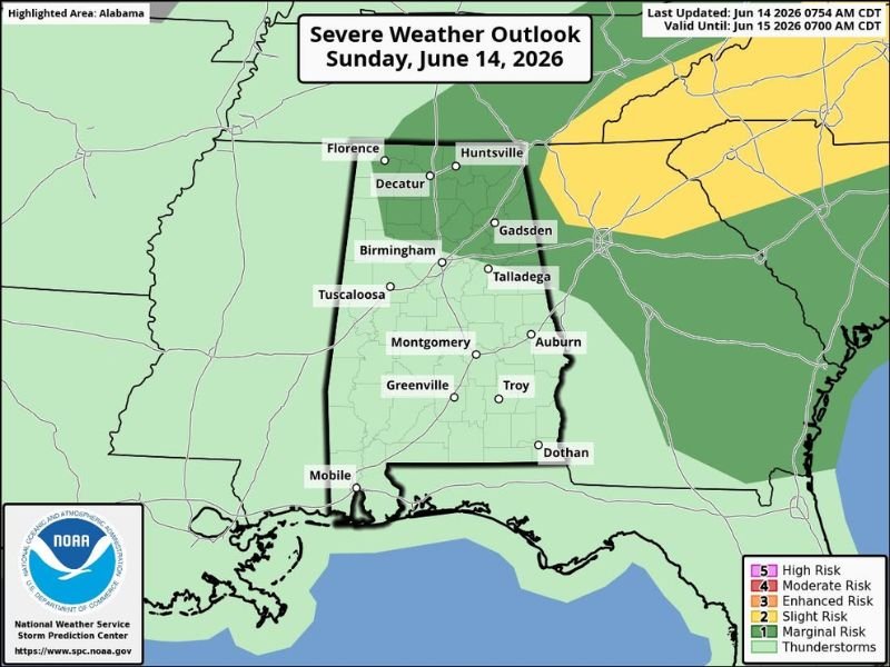
North Alabama Including Huntsville and Florence Under Marginal Risk Today
The Marginal Risk zone for severe weather today covers a corridor across North Alabama including Florence, Decatur, Huntsville, and extending toward Gadsden and Talladega. Gusty winds are the primary concern with any storm that becomes strong this afternoon and into tonight.
Not everyone across the state will see rain today, but the highest coverage of showers and storms is expected over this northern portion of Alabama through the afternoon and evening hours.
Statewide Rain Totals of 3 to 5 Inches Possible Over the Next Seven Days
Looking at the broader pattern, the seven-day rainfall outlook shows widespread totals of 3 to 5 inches across nearly the entire state of Alabama, with some areas in the west-central and northern portions potentially seeing totals as high as 6.5 to 8 inches. Tropical moisture feeding into the Deep South combined with a couple of surface boundaries will keep rain chances elevated through the week.
Cities including Birmingham, Tuscaloosa, Montgomery, Auburn, and Mobile are all within the zone expected to see meaningful rainfall accumulation over the coming week, though it will not rain everywhere all day.
Cooler Temperatures Expected Through the Week
Heat levels will moderate through the week ahead, with highs running in the 80s across Alabama rather than the intense heat seen recently. While the cooler temperatures offer some relief, the elevated rain chances mean outdoor plans should be flexible through the coming days. Stay with NapervilleLocal.com for the latest weather updates and local forecast coverage.

I’ve lived in Naperville long enough to see how quickly our community changes — from new developments downtown to sudden shifts in our Midwest weather. Reporting on Naperville news and daily forecasts gives me the chance to keep neighbors informed about what really matters. My goal is simple: deliver clear, timely updates so you always know what’s happening in our city and what to expect from the skies above.