
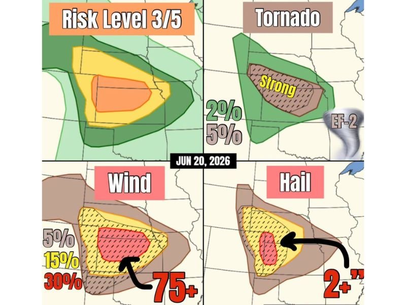
Enhanced Risk Level 3 Significant Severe Weather Targets Nebraska and Kansas With Strong EF-2 Tornadoes, 2+ Inch Hail, and 75+ MPH Winds
NEBRASKA/KANSAS — A significant, all-modes severe weather event is expected today across the central and high plains, with a Level 3 of 5 Enhanced Risk in place. Supercells may first form in southeastern Wyoming and northeast Colorado before tracking into Nebraska and Kansas, initially producing very large hail as the primary mode. As moisture and shear increase later in the day, tornado potential rises significantly, with some strong EF-2 tornadoes possible if supercells remain discrete.
Strong EF-2 Tornado Potential Increases as Storms Track Into Nebraska and Kansas
The tornado probability map shows a brown zone with 5% probability where strong EF-2 tornadoes are explicitly possible, centered over the Nebraska-Kansas border region with a broader 2% zone extending across a wider area. Supercells originating in southeastern Wyoming and northeast Colorado carry the greatest tornado risk as they track eastward and encounter increasing moisture and shear later in the day.
The Level 3 Enhanced Risk core sits over the same corridor, with the highest orange zone centered over western Nebraska and extending into northeast Colorado and western Kansas.
Wind Gusts Over 75 MPH and Hail Over 2 Inches Possible With Bow Echo Tonight
As the evening progresses, an intense bow echo or squall line is expected to form, bringing sweeping destructive straight-line winds and the potential for QLCS tornadoes overnight. The wind probability map shows a 30% chance of damaging winds exceeding 75 mph within the highlighted red zone, with a broader 15% zone surrounding it.
Large hail exceeding 2 inches in diameter is also probable within the same corridor, with a 30% probability in the core zone tracking from northeast Colorado into Nebraska and Kansas.
Separate Storm Batch Possible Across Northern Kansas
Forecasters are also watching for a separate batch of storms that may initiate across northern Kansas, though guidance differs on this scenario given less pronounced surface features. If this separate development occurs, all severe modes including hail, wind, and tornadoes would remain possible there as well.
Stay with NapervilleLocal.com for the latest weather updates and local forecast coverage.

I’ve lived in Naperville long enough to see how quickly our community changes — from new developments downtown to sudden shifts in our Midwest weather. Reporting on Naperville news and daily forecasts gives me the chance to keep neighbors informed about what really matters. My goal is simple: deliver clear, timely updates so you always know what’s happening in our city and what to expect from the skies above.