
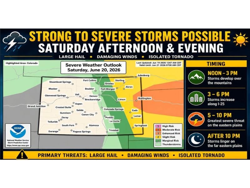
Hottest Day of the Weekend Hits Colorado’s Eastern Plains at 90 to 102° as Large Hail, Damaging Winds, and Isolated Tornado Threaten This Saturday Evening
COLORADO — Saturday is shaping up to be the hottest day of the weekend across Colorado and the surrounding region, with temperatures reaching 90 to 102°F across the eastern plains and 88 to 102°F on the Western Slope. This heat also marks the start of a more active weather pattern, as scattered thunderstorms develop over the mountains and foothills early this afternoon before increasing along I-25 and pushing onto the eastern plains, where the greatest severe weather threat develops this evening.
Storm Timeline Moves From Mountains to Eastern Plains Through the Day
Storms develop first over the mountains and Continental Divide between noon and 3 PM, where temperatures will range from 60 to 82°F with lightning the main concern and brief heavy rain possible. Storms then increase along the Foothills and Front Range I-25 corridor between 3 and 6 PM, with highs reaching 88 to 100°F and gusty outflow winds and frequent lightning developing.
The greatest severe weather threat shifts to the eastern plains between 5 and 10 PM, where temperatures of 90 to 102°F combine with the most volatile atmosphere of the day.
Eastern Plains Including Western Nebraska and Western Kansas Face Main Severe Threat
Areas east of I-25, especially across eastern Colorado and into portions of western Nebraska and western Kansas, face the primary severe weather risk this evening. Large hail, damaging wind gusts, and an isolated tornado cannot be ruled out with the strongest storms in this zone.
Not everyone in the broader region will see severe weather today, but anyone living east of I-25 should keep a close eye on the sky later today and into tonight.
SE Wyoming and Western Slope See Lower Storm Coverage
SE Wyoming and the I-80 Corridor are forecast for 75 to 88°F with a few strong storms possible, bringing hail, wind, and lightning. The Western Slope remains hot and dry at 88 to 102°F with only isolated storms and windy conditions at times, with little overall storm coverage expected there today.
Stay with NapervilleLocal.com for the latest weather updates and local forecast coverage.

I’ve lived in Naperville long enough to see how quickly our community changes — from new developments downtown to sudden shifts in our Midwest weather. Reporting on Naperville news and daily forecasts gives me the chance to keep neighbors informed about what really matters. My goal is simple: deliver clear, timely updates so you always know what’s happening in our city and what to expect from the skies above.