
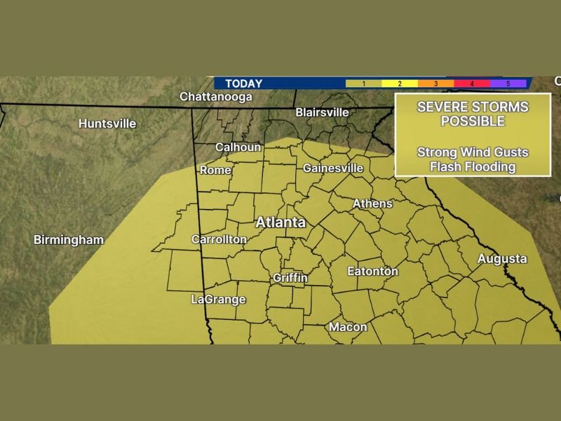
Damaging Wind Gusts and Flash Flooding Targeting North and Central Georgia Including Atlanta, Gainesville, and Rome With Threat Increasing This Afternoon and Evening
NORTH AND CENTRAL GEORGIA — A stormy and dangerous weather pattern continues across north and central Georgia on Sunday, May 24, 2026, with strong to severe storms capable of producing damaging wind gusts and flash flooding expected to intensify through the afternoon and evening hours. The severe threat zone covers a broad corridor from the Tennessee border southward through Atlanta, Carrollton, Griffin, and Macon, with the risk increasing considerably as the day progresses.
Severe Storm Threat Increasing This Afternoon Across the Atlanta Corridor and Surrounding Areas
The stormy pattern already in place this morning is expected to intensify through the afternoon and evening hours, raising the severe storm threat across the entire risk zone. Atlanta sits squarely within the active severe threat area along with surrounding communities including Carrollton, Rome, Calhoun, and Gainesville.
Storms developing through the afternoon will have enough atmospheric support to produce damaging wind gusts capable of downing trees and powerlines across the metro and surrounding counties. Residents across the Atlanta corridor should have a shelter plan identified and ready well before afternoon storm activity develops.
Damaging Wind Gusts and Flash Flooding Identified as the Two Primary Hazards Sunday
Strong wind gusts and flash flooding are the two headline hazards associated with today’s severe weather threat across north and central Georgia. The combination of these two threats makes Sunday a particularly dangerous weather day, as wind damage and rapidly rising water can both develop with little warning time.
Areas including Athens, Eatonton, Griffin, and LaGrange fall within the active risk zone and should monitor conditions closely through the afternoon and evening. Any location that has already received significant rainfall in recent days carries an elevated flash flood risk as new heavy rain arrives on already-saturated ground.
Broad Severe Risk Zone Stretches From Chattanooga Border Through Macon Sunday
The severe threat area stretches from near the Chattanooga and Blairsville zones in the north all the way southward through Macon, covering virtually all of north and central Georgia within the active risk corridor. Communities from Rome and Calhoun through the core of Atlanta and southward toward LaGrange and Macon are all within the Level 1 severe zone today.
Staying connected to local weather alerts and monitoring rapidly evolving radar trends through the afternoon and evening is critical for all residents across the risk zone. Outdoor Memorial Day weekend plans across north and central Georgia should include a weather safety component and a clear plan to seek shelter when storms approach. Stay with NapervilleLocal.com for the latest weather updates and local forecast coverage.

I’ve lived in Naperville long enough to see how quickly our community changes — from new developments downtown to sudden shifts in our Midwest weather. Reporting on Naperville news and daily forecasts gives me the chance to keep neighbors informed about what really matters. My goal is simple: deliver clear, timely updates so you always know what’s happening in our city and what to expect from the skies above.