
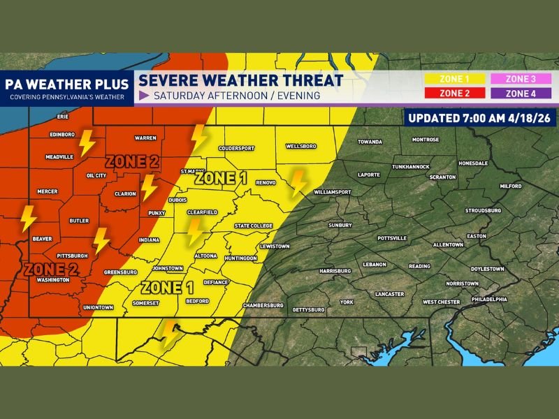
Damaging Wind Gusts and Spin-Up Tornado Risk Targeting Western Pennsylvania Including Pittsburgh and Erie Saturday 3-9 PM as Strong Cold Front Pushes Through
WESTERN PENNSYLVANIA — A strong cold front will pose a significant severe weather risk across western Pennsylvania this Saturday afternoon and evening, with the best timing window running from 3 PM through 9 PM. Enough instability and wind shear will be in place ahead of the front to create a potentially severe squall line capable of producing damaging wind gusts and a non-zero spin-up tornado risk. As the front pushes into central Pennsylvania it will encounter more stable air and begin falling apart, limiting the severe weather threat to the western portions of the state.
Zone 2 Faces the Greatest Threat — Pittsburgh, Erie, and Surrounding Areas
Zone 2, covering the highest risk area across western Pennsylvania, includes Pittsburgh, Erie, Meadville, Edinboro, Oil City, Mercer, Butler, Beaver, Washington, Greensburg, and Uniontown. Scattered strong to severe thunderstorms are expected across this zone during the afternoon and evening window.
The strongest storms within Zone 2 may pack wind gusts of 55 to 65 MPH, capable of downing trees, snapping power lines, and causing structural damage across affected communities. Torrential downpours and frequent lightning will accompany even the non-severe storms across this zone throughout the 3 to 9 PM window.
Zone 1 Covers Central Pennsylvania With Isolated Severe Risk
Zone 1 stretches across central Pennsylvania including DuBois, Punxsy, Clearfield, State College, Altoona, Huntingdon, Johnstown, Somerset, Bedford, Defiance, and Chambersburg. Isolated strong to severe thunderstorms are expected across this zone, with a somewhat lower threat level compared to the Zone 2 corridor further west.
Wind gusts of 50 to 60 MPH are possible with the strongest Zone 1 storms, along with torrential downpours and lightning. As the front encounters increasingly stable air pushing into central Pennsylvania, storm organization and intensity are expected to drop off compared to what is anticipated across the western zone.
Spin-Up Tornado Risk Adds to the Threat Picture
Beyond the damaging wind threat, a non-zero spin-up tornado risk exists across western Pennsylvania as the squall line pushes through during the afternoon and evening. The combination of wind shear ahead of the cold front and any embedded mesovortices within the squall line creates the potential for brief and weak tornado spin-ups across Zone 2 communities.
Residents across Pittsburgh, Erie, and the broader Zone 2 corridor should treat any tornado warnings issued this afternoon with the same urgency as any other tornado event, regardless of the expected brief nature of any potential spin-up.
Front Weakens as It Enters Central Pennsylvania
An important aspect of today’s setup is that the severe weather threat is geographically limited to western and portions of central Pennsylvania. As the cold front tracks eastward into central Pennsylvania it will encounter a more stable air mass, causing the squall line to lose organization and intensity rapidly.
Communities across eastern Pennsylvania including Scranton, Allentown, Philadelphia, and surrounding areas are not expected to see significant severe weather impacts from today’s system, with the front arriving in a much weaker state by the time it reaches those eastern zones.
Be Prepared Before 3 PM Across Western Pennsylvania
With the storm window opening at 3 PM today, residents across western Pennsylvania should have all severe weather preparations finalized well before the afternoon hours. Identify shelter locations, have multiple ways to receive weather alerts active, and remain flexible with any outdoor plans scheduled for Saturday afternoon and evening across the Zone 1 and Zone 2 corridors. Stay with NapervilleLocal.com for the latest weather updates and local forecast coverage.

I’ve lived in Naperville long enough to see how quickly our community changes — from new developments downtown to sudden shifts in our Midwest weather. Reporting on Naperville news and daily forecasts gives me the chance to keep neighbors informed about what really matters. My goal is simple: deliver clear, timely updates so you always know what’s happening in our city and what to expect from the skies above.