
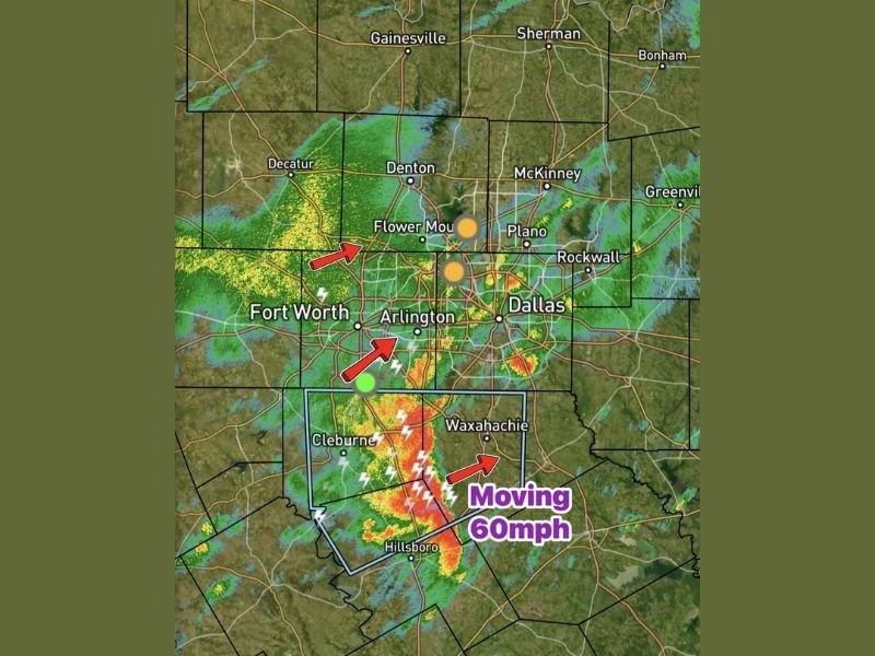
Strong Storm Moving Through Red Oak and Hillsboro at 60 MPH Saturday Morning With 50 MPH Gusts and Pea-Size Hail Targeting Dallas-Fort Worth Metroplex
DALLAS-FORT WORTH METROPLEX, TEXAS — A 9 AM Saturday update confirms that another batch of showers is moving northeast into the Dallas-Fort Worth metroplex this morning, with stronger storm activity now concentrated south of I-20. A particularly active storm near Red Oak is currently moving east at 60 MPH, producing wind gusts around 50 MPH and pea-size hail as it tracks rapidly through the southern portions of the metro area.
Fast-Moving Storm Targets South of I-20 Corridor
The strongest storm activity as of 9 AM has shifted south of I-20, with radar showing intense returns concentrated near Red Oak and Hillsboro. The storm is moving eastward at an unusually fast 60 MPH, meaning communities in its path will experience rapid onset conditions with very little time between the first signs of weather and peak storm intensity.
The fast movement of the cell reduces the duration of impacts at any single location but also compresses the warning window significantly, making it critical for residents along the storm’s path to act immediately upon any warnings being issued.
50 MPH Gusts and Pea-Size Hail With the Strongest Cell
The Red Oak storm is currently producing two notable hazards as it races eastward. Wind gusts around 50 MPH are capable of causing minor tree damage, moving lightweight outdoor objects, and creating briefly dangerous driving conditions across the southern metro corridor.
Pea-size hail is also accompanying the stronger cell, posing a nuisance-level hail threat to vehicles and outdoor property across communities in the storm’s immediate path south of I-20 including Waxahachie, Hillsboro, and surrounding areas.
Second Batch of Showers Moving Northeast Into the Metroplex
Beyond the stronger southern storm, a second batch of showers is simultaneously moving northeast into the broader Dallas-Fort Worth metroplex as of the 9 AM update. Radar shows widespread green and yellow returns across communities including Fort Worth, Arlington, Flower Mound, Denton, Plano, and Dallas, indicating moderate rainfall pushing through the northern and central portions of the metro area.
Lightning activity is embedded within portions of this broader shower activity, particularly visible across the Fort Worth and Arlington corridor on radar, adding a lightning safety concern for anyone caught outdoors across the metro this morning.
Fort Worth, Arlington, and Dallas See Widespread Shower Activity
The broader shower band moving northeast is impacting a wide swath of the metroplex simultaneously. Fort Worth and Arlington are seeing active radar returns as of 9 AM, with the shower activity extending northward through Flower Mound and toward Denton while also pushing eastward into the Dallas, Plano, and Rockwall areas.
Residents across the entire metroplex should expect wet and unsettled conditions through the morning hours as both the southern stronger cell and the broader northeastern shower band continue tracking through the region. Stay with NapervilleLocal.com for the latest weather updates and local forecast coverage.

I’ve lived in Naperville long enough to see how quickly our community changes — from new developments downtown to sudden shifts in our Midwest weather. Reporting on Naperville news and daily forecasts gives me the chance to keep neighbors informed about what really matters. My goal is simple: deliver clear, timely updates so you always know what’s happening in our city and what to expect from the skies above.