
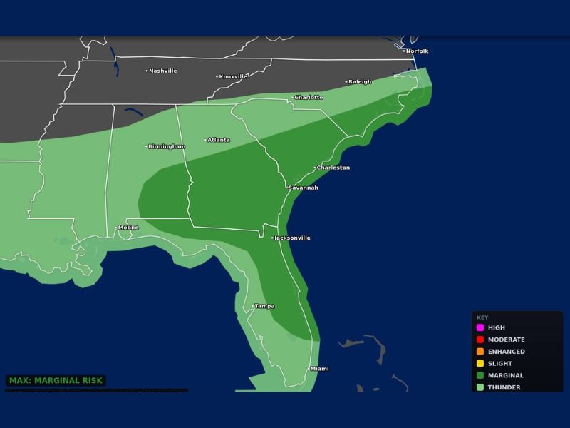
Damaging Winds, Hail and Isolated Tornado Possible From Gulf Coast Through the Carolinas Including Atlanta, Savannah and Charlotte Monday May 11 Under Marginal Risk Outlook
SOUTHEAST — A low-end severe weather threat is in place for Monday, May 11, 2026, stretching from the Gulf Coast through the Carolinas with a few stronger storms possible during the afternoon and evening hours. The categorical outlook updated at 10:18 AM ET places a Marginal Risk zone across a broad corridor covering Birmingham, Atlanta, Savannah, Jacksonville, Charleston, Charlotte, and Raleigh. Damaging winds, hail, and an isolated tornado cannot be ruled out as storms develop through Monday afternoon and evening across the risk zone.
Marginal Risk Covers Broad Corridor From Gulf Coast Through Atlanta and Carolinas
The Marginal Risk zone stretches from Mobile and the Gulf Coast through Atlanta, Savannah, and Jacksonville northeastward through Charleston, Charlotte, and Raleigh toward Norfolk on the Virginia coast. This broad geographic footprint means millions of residents across multiple southeastern states fall inside the Monday storm risk area.
While the overall threat is low-end and not a major severe weather setup, any storm developing within the risk zone carries the potential to produce damaging winds and hail through the afternoon and evening hours.
Damaging Winds and Hail Primary Threats With Isolated Tornado Not Ruled Out
Damaging winds and hail are the primary hazards being monitored for Monday across the Southeast risk zone. An isolated tornado cannot be completely ruled out, particularly across the inner Marginal Risk zone where storm organization is most likely to reach severe criteria during the peak afternoon heating hours.
The overall tornado probability remains low, but residents across Atlanta, Savannah, Jacksonville, and Charlotte should treat any tornado warning issued Monday with the same urgency regardless of the low-end nature of the overall setup.
Thunder Zone Extends Through Florida Including Tampa and Miami Monday
The general thunder and storm zone extends well southward through Florida, covering Tampa and Miami in the broader storm coverage area for Monday. While severe weather potential is lower across Florida than the core Marginal Risk zone to the north, storm development and lightning remain possible across the Florida peninsula through Monday afternoon and evening as the system moves through the region.
Stay with NapervilleLocal.com for the latest weather updates and local forecast coverage.

I’ve lived in Naperville long enough to see how quickly our community changes — from new developments downtown to sudden shifts in our Midwest weather. Reporting on Naperville news and daily forecasts gives me the chance to keep neighbors informed about what really matters. My goal is simple: deliver clear, timely updates so you always know what’s happening in our city and what to expect from the skies above.