
Damaging Winds, Large Hail, and Tornado Threat Targeting Kentucky and Indiana Including Louisville and Evansville With Severe Weather Pushing East Through Today and Tonight
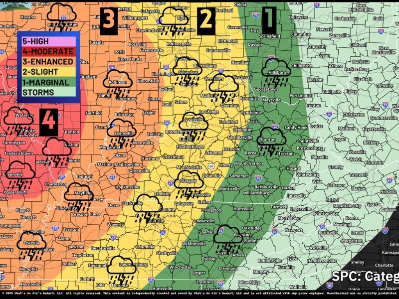
KENTUCKY AND INDIANA — All types of severe weather are possible across Kentucky and Indiana today, Monday, April 27, 2026, as a powerful storm system pushes eastward through the region. The setup is strongest to the west where storms are more organized and capable of the biggest impacts, but significant hazards will continue to shift eastward through the afternoon and evening hours. Damaging winds are the primary concern for Kentucky as storms transition into a more linear structure, while hail and tornado threats are more elevated for areas farther west where storms remain isolated.
Damaging Winds Are the Primary Threat as Storms Organize Into a Line Moving East
As storms move east into Kentucky they are expected to organize into a squall line, a structure that strongly favors widespread damaging wind gusts over tornado or hail production. Severe wind probabilities of at least 60 miles per hour reach 45 to 59 percent across the western portions of the region, dropping to 15 to 29 percent farther east across central Kentucky and Indiana.
Strong wind gusts remain possible even as storms lose peak intensity during their eastward progression. Residents across Louisville, Evansville, and surrounding communities should be prepared for damaging gusts capable of downing trees and power lines as the line pushes through later today and tonight.
Hail Threat Highest Earlier and to the West Before Storms Organize
Quarter-sized hail probabilities reach 30 to 44 percent across western portions of the threat area where storms are expected to remain more isolated during the early stages of the event. This isolated supercell mode early in the day is the window when hail production is most favored before storm consolidation into a line reduces that threat.
Hail chances drop to 15 to 29 percent and 5 to 14 percent farther east as storm organization increases through the afternoon. Areas across central Indiana and central Kentucky will see a diminishing hail threat as the primary severe mode shifts toward wind damage.
Tornado Risk Present but Secondary Concern With Better Chances Staying West
A tornado risk exists across the region today with probabilities reaching 10 to 14 percent across western areas and dropping to 2 to 9 percent farther east. The tornado threat is not the primary concern locally, as the linear storm mode favors wind damage over tornado production as the system pushes into Kentucky and Indiana.
The better tornado chances remain anchored to the west where supercells can sustain themselves longer before merging into the line. Residents should not dismiss the tornado risk entirely, as any embedded supercell within the line can still produce a brief tornado with limited warning time. Stay with NapervilleLocal.com for the latest weather updates and local forecast coverage.

I’ve lived in Naperville long enough to see how quickly our community changes — from new developments downtown to sudden shifts in our Midwest weather. Reporting on Naperville news and daily forecasts gives me the chance to keep neighbors informed about what really matters. My goal is simple: deliver clear, timely updates so you always know what’s happening in our city and what to expect from the skies above.