
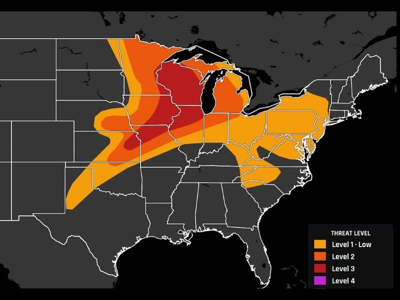
Level 3 Enhanced Risk Severe Weather Outbreak Targets Wisconsin, Iowa, and Illinois With EF2+ Tornadoes, 2″+ Hail, and 75 MPH Winds Possible Through Tonight
MIDWEST — A significant severe weather outbreak is underway across Wisconsin, Iowa, and Illinois today, June 10, 2026, with the Storm Prediction Center maintaining a Level 3 of 5 Enhanced Risk through this evening and overnight. Storms already fired predawn over Iowa, and the main event is expected to unfold late this afternoon along a cold front, bringing supercells capable of large hail, strong tornadoes, and damaging winds in multiple rounds.
Supercells Firing Along Cold Front This Afternoon
The primary severe weather window arrives late afternoon as supercells develop along the cold front cutting through the region. These storms are capable of producing hail exceeding two inches in diameter and tornadoes potentially reaching EF2+ intensity.
The highest risk on the SPC outlook — shown in deep red — is focused over Wisconsin and northern Illinois, with the broader Enhanced Risk corridor stretching across Iowa and into the surrounding region. Anyone in these areas needs to be weather-ready well before storms arrive.
Multiple Rounds Possible Into Tonight Due to Morning Storm Activity
A complicating factor today is the pre-dawn storm activity that fired over Iowa earlier this morning. That activity is expected to influence where new storms redevelop near the Iowa and Illinois border, potentially seeding additional rounds of severe weather through the evening and overnight hours.
This multi-round setup means the threat does not end when the afternoon supercell window closes. Residents should remain alert through the late evening hours and not let their guard down after the first wave passes.
75 MPH Wind Gusts Add to the Danger
In addition to the tornado and hail threats, wind gusts topping 75 mph are possible as storms evolve and organize through the evening. Clusters and line segments moving through the region could produce widespread damaging winds across Wisconsin, Iowa, and Illinois.
Secure any loose outdoor items, charge devices in advance, and have multiple ways to receive severe weather alerts throughout the day and into tonight. This is a high-impact weather day for the region. Stay with NapervilleLocal.com for the latest weather updates and local forecast coverage.

I’ve lived in Naperville long enough to see how quickly our community changes — from new developments downtown to sudden shifts in our Midwest weather. Reporting on Naperville news and daily forecasts gives me the chance to keep neighbors informed about what really matters. My goal is simple: deliver clear, timely updates so you always know what’s happening in our city and what to expect from the skies above.