
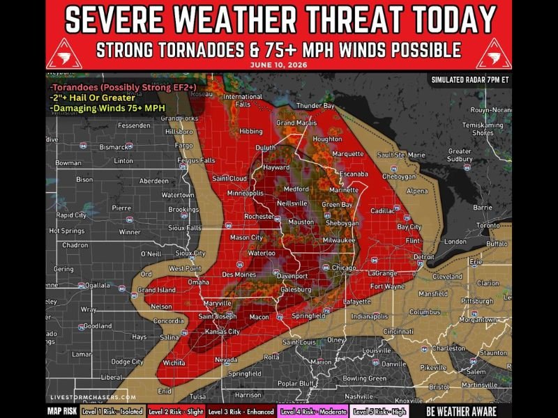
Enhanced Risk Level 3 Severe Weather Threat Targets Minnesota, Wisconsin, Iowa, Illinois, and Missouri With Strong Tornadoes, 2″+ Hail, and 75+ MPH Winds Today
MIDWEST — A significant severe weather outbreak is underway across the Upper Mississippi Valley and Midwest today, June 10, 2026, with an Enhanced Risk (Level 3 of 5) in place from Minnesota and Wisconsin southward through Iowa, Illinois, and Missouri. Scattered to numerous severe thunderstorms are expected this afternoon and evening, carrying a triple threat of strong tornadoes, very large hail, and damaging winds.
Strong Tornadoes Possible With Sustained Supercells This Afternoon
Tornadoes are a confirmed primary threat today, with some potentially reaching EF2+ intensity. Sustained supercells developing this afternoon carry the highest tornado potential, particularly across the core of the Enhanced Risk zone spanning the Minneapolis to Chicago corridor.
Residents across Minnesota, Wisconsin, and northern Illinois should treat this threat seriously and have multiple ways to receive watches and warnings before storms arrive in their area.
Very Large Hail and Damaging Winds Round Out the Triple Threat
Initial supercells are capable of producing hail in excess of 2 inches in diameter during the afternoon hours. As storms evolve into clusters and line segments through the evening, the damaging wind threat increases significantly, with gusts potentially exceeding 75 mph.
Cities including Minneapolis, Green Bay, Milwaukee, Des Moines, Waterloo, Davenport, Chicago, and Springfield all fall within or near the highest-risk zone. Additional rounds of severe storms remain possible overnight, continuing the hail and wind threat into the late hours.
Timeline for Today’s Severe Weather Threat
Severe storms are expected to first develop across portions of Minnesota, Wisconsin, Iowa, Illinois, and Missouri during the afternoon. Supercells capable of large hail and strong tornadoes become most likely during the late afternoon and evening hours.
By evening into overnight, storms are forecast to grow into larger clusters with the damaging wind threat becoming the dominant concern. Anyone with outdoor plans today should monitor conditions closely and have a shelter plan ready well in advance. Stay with NapervilleLocal.com for the latest weather updates and local forecast coverage.

I’ve lived in Naperville long enough to see how quickly our community changes — from new developments downtown to sudden shifts in our Midwest weather. Reporting on Naperville news and daily forecasts gives me the chance to keep neighbors informed about what really matters. My goal is simple: deliver clear, timely updates so you always know what’s happening in our city and what to expect from the skies above.