
Damaging Wind Gusts 60-70 MPH and Brief Tornado Possible Across Eastern Ohio and Western Pennsylvania Saturday Starting as Early as 1 PM
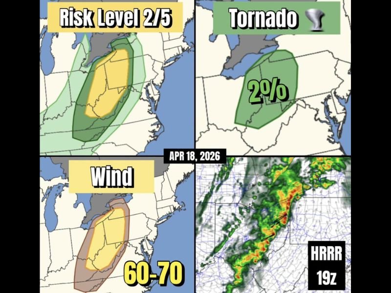
EASTERN OHIO AND WESTERN PENNSYLVANIA — A Slight Risk Level 2 out of 5 severe weather area is in place for eastern Ohio and western Pennsylvania this Saturday, April 18, 2026, as a cold front continues pushing eastward across the region. While activity will not be nearly as intense as the last several days, a few severe storms capable of damaging wind gusts and a brief weak tornado will be possible starting as early as 1 PM today, arriving progressively later the further east you go.
Storms Arrive From 1 PM Onward Moving East
The timing of today’s severe weather threat begins as early as 1 PM across eastern Ohio, with storm activity arriving progressively later across western Pennsylvania as the cold front continues its eastward march through the afternoon and evening hours. Residents further east should plan for a later arrival of any storm activity but should remain weather-aware throughout the entire afternoon regardless of location within the risk zone.
The HRRR model data shows a well-defined line of storm activity already organized and tracking eastward, confirming the likelihood of storm impacts across the outlined risk area during the afternoon hours today.
Wind Gusts of 60 to 70 MPH Are the Primary Threat
The dominant hazard with today’s storm system is damaging straight-line wind gusts ranging from 60 to 70 MPH across the risk zone covering eastern Ohio and western Pennsylvania. Wind gusts of this magnitude are capable of downing trees, snapping branches, damaging structures, and knocking out power across affected communities.
The wind threat zone on today’s outlook map covers a concentrated corridor centered over eastern Ohio and extending into western Pennsylvania, with the highest wind gust probabilities focused within that core area during the afternoon storm window.
Brief Weak Tornado Cannot Be Ruled Out
Beyond the wind threat, a 2% tornado probability has been identified across eastern Ohio and western Pennsylvania for today. While the overall tornado risk is low and any tornado that develops is expected to be brief and weak, the possibility cannot be completely dismissed as the cold front interacts with the unstable air mass across the region.
Residents across the risk zone should have a shelter plan ready before 1 PM today and be prepared to act quickly if a tornado warning is issued for their specific location during the afternoon hours.
Slight Risk 2/5 Covers the Core of Eastern Ohio and Western Pennsylvania
Today’s Risk Level 2 out of 5 Slight Risk designation covers the core zone of eastern Ohio and western Pennsylvania, with a surrounding Marginal Risk area extending outward across neighboring states. The yellow core zone represents the area with the highest confidence in organized severe storm development today.
The overall threat level today is considerably lower compared to the multi-day severe weather outbreak that impacted the broader region over the past several days, offering some relief to residents who have been on high alert throughout the week.
Remain Alert Through the Afternoon and Early Evening
Despite the lower overall threat level compared to recent days, today’s storms should still be taken seriously across eastern Ohio and western Pennsylvania. Have multiple ways to receive weather alerts active, stay aware of changing conditions throughout the afternoon, and be prepared to seek shelter immediately if warnings are issued for your area. Stay with NapervilleLocal.com for the latest weather updates and local forecast coverage.

I’ve lived in Naperville long enough to see how quickly our community changes — from new developments downtown to sudden shifts in our Midwest weather. Reporting on Naperville news and daily forecasts gives me the chance to keep neighbors informed about what really matters. My goal is simple: deliver clear, timely updates so you always know what’s happening in our city and what to expect from the skies above.