
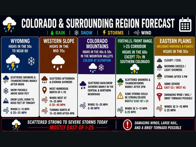
Strong to Severe Storms With Damaging Winds, Large Hail, and Brief Tornado Possible Targeting Colorado and Wyoming Eastern Plains Including Eastern Colorado and Western Kansas
COLORADO AND SURROUNDING REGION — A potent storm system pinwheeling across Wyoming on Thursday, May 21, 2026, is setting the stage for scattered strong to severe thunderstorms across Colorado and the surrounding region, with the greatest threat focused east of I-25 including eastern Colorado and western Kansas after 2PM. Damaging winds, large hail, and a brief tornado are all possible across the eastern plains as a dry line clash between drier mountain air and humid southeast flow creates prime convective conditions through the afternoon and evening.
Greatest Severe Weather Threat Focused East of I-25 and Into Western Kansas After 2PM
The eastern plains, including portions of Nebraska and Kansas, carry the highest severe weather risk Thursday afternoon and evening. High-resolution forecast models are showing convective initiation on or after 2PM, with storms capable of producing damaging winds, large hail, and a brief tornado across eastern Colorado and western Kansas.
Winds across the eastern plains will be out of the southeast at 5 to 15 mph with gusts to 25 mph ahead of the approaching system. Once storms fire after 3PM, conditions can deteriorate quickly and anyone in the eastern plains corridor should have a shelter plan ready well before afternoon arrives.
Foothills and Front Range I-25 Corridor Faces Scattered Strong Storm Chances After 2PM
Scattered showers and thunderstorms are also expected across the foothills and the Front Range I-25 corridor mainly after 2PM on Thursday. Some storms in this zone could reach strong to severe levels, particularly for locations east of I-25, with southeast winds of 5 to 15 mph and gusts to 25 mph.
Southern Colorado communities along the Front Range corridor will see highs reaching into the 70s, while the broader I-25 zone tops out in the 60s. The storm threat here is secondary to the eastern plains but remains real enough to warrant afternoon weather awareness across the Denver metro and surrounding areas.
Wyoming Storm System Drives Westerly Mountain Winds and Snow Above 8000 Feet Thursday
The potent storm system tracking across Wyoming today is generating westerly winds across the Colorado mountains, with scattered rain and snow showers expected mainly across the central and northern mountain ranges. Snow remains possible above 8000 feet, with snow levels dropping to 6000 feet by tonight as the system pushes through.
Mountain valley highs will settle into the 40s and 50s with winds of 15 to 25 mph and gusts to 40 mph. The western slope will see scattered afternoon and evening showers most numerous north of I-70, with winds west at 15 to 25 mph gusting to 35 to 45 mph before turning north at 15 to 25 mph after 4PM.
Unsettled Pattern Continues Through Memorial Day With Storms Expected Into Next Week
Friday brings departure of the main storm system but very blustery conditions will follow in its wake across the region. Lingering shower and storm chances persist Friday and Saturday, favoring the southern half of the region, with only isolated activity expected Sunday before scattered showers and thunderstorms return for Memorial Day Monday.
The unsettled pattern is forecast to continue through next week, keeping storm chances elevated on a recurring basis. Residents across Colorado and the surrounding region should plan for ongoing weather awareness through the holiday weekend and remain connected to local forecast updates as conditions continue to evolve.
Stay with NapervilleLocal.com for the latest weather updates and local forecast coverage.

I’ve lived in Naperville long enough to see how quickly our community changes — from new developments downtown to sudden shifts in our Midwest weather. Reporting on Naperville news and daily forecasts gives me the chance to keep neighbors informed about what really matters. My goal is simple: deliver clear, timely updates so you always know what’s happening in our city and what to expect from the skies above.