
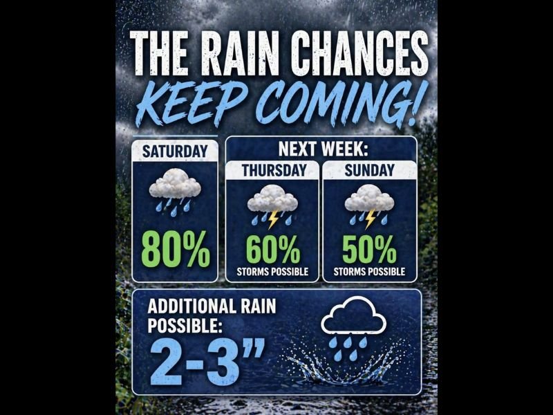
Multiple Rounds of Rain and Storms Delivering 2 to 3 Additional Inches With 80 Percent Rain Chance Saturday and Storms Possible Thursday and Sunday Next Week
REGIONAL — A much-needed and sustained wet pattern is taking shape with strong indications that rain chances will keep coming through this weekend and well into next week. Saturday carries an 80 percent rain chance, followed by a 60 percent storm chance next Thursday and a 50 percent storm chance next Sunday, creating multiple windows of meaningful rainfall opportunity across the region. Additional rainfall accumulations of 2 to 3 inches are possible across the extended period, and temperatures will be running below normal just about every day through the pattern.
Saturday Brings the Highest Rain Probability at 80 Percent to Start the Weekend
The most immediate and highest-confidence rainfall opportunity arrives this Saturday, where an 80 percent rain chance reflects strong model agreement on a significant and widespread rainfall event for the region. This level of probability indicates that the vast majority of communities in the forecast area will see measurable rainfall on Saturday, making it the anchor event of this week’s wet pattern.
The Saturday rain event is not expected to be a complete washout but rather a steady and widespread rainfall producer that will contribute meaningfully to the overall 2 to 3 inch additional accumulation potential being highlighted through the extended period. Outdoor plans for Saturday should account for persistent wet conditions through the day.
Next Thursday Brings a 60 Percent Storm Chance as Active Pattern Continues Into Next Week
The wet pattern does not end with the weekend, as next Thursday carries a 60 percent storm chance with thunder indicated in the forecast graphic. This midweek storm opportunity represents the continuation of a below-normal temperature and above-normal rainfall pattern that forecasters indicate has strong signals for persistence through the week ahead.
The Thursday storm chance adds another significant rainfall opportunity to an already active pattern, increasing the probability that cumulative totals through the extended period could reach or exceed the 2 to 3 inch range highlighted in the forecast. Communities that miss out on Saturday’s rain will have additional opportunities through the week.
Below Normal Temperatures Accompany the Wet Pattern Through Next Week
Beyond the rainfall opportunities, temperatures are expected to run below normal nearly every day through the extended wet pattern, creating a cool and unsettled stretch that is a welcome departure from the warm and dry conditions that have dominated the region recently. The combination of cooler temperatures and repeated rainfall events makes this pattern particularly beneficial for drought-stressed areas across the region.
Next Sunday rounds out the active period with a 50 percent storm chance, extending the rain and storm opportunities through the full weekend of next week. The persistence of this wet pattern across multiple days and systems is exactly the kind of sustained moisture delivery that can make a meaningful impact on drought conditions and soil moisture deficits across the affected region. Stay with NapervilleLocal.com for the latest weather updates and local forecast coverage.

I’ve lived in Naperville long enough to see how quickly our community changes — from new developments downtown to sudden shifts in our Midwest weather. Reporting on Naperville news and daily forecasts gives me the chance to keep neighbors informed about what really matters. My goal is simple: deliver clear, timely updates so you always know what’s happening in our city and what to expect from the skies above.