
Scattered Showers and Coastal Thunderstorms Moving Through Southeastern North Carolina Including Fayetteville, Wilmington, and Jacksonville Through Early Afternoon Thursday
SOUTHEASTERN NORTH CAROLINA — Scattered showers are continuing to move across parts of Southeastern North Carolina this Thursday morning, April 30, 2026, with activity expected to persist in scattered fashion through the early afternoon hours.
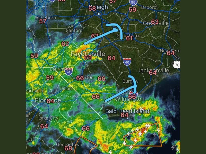
Radar imagery captured at 9:49 AM shows shower coverage concentrated across the Fayetteville, Wilmington, and Jacksonville corridors, with a more active thunderstorm cluster visible along and just offshore of the coast near Bald Head Island and the southeastern corner of the state. Temperatures across the affected area are running in the low to mid 60s with Fayetteville at 65 and Wilmington holding at 66 degrees.
Scattered Showers Persisting Across the Fayetteville and Wilmington Corridor This Morning
The primary shower activity as of mid-morning is concentrated across the southeastern portion of North Carolina, with radar showing a band of showers moving through the Fayetteville, Lumberton, Burgaw, and Wilmington areas. Two distinct shower hooks are visible on radar near the Goldsboro and Wilmington areas, indicating areas of more organized shower development within the broader scattered coverage across the region.
Shower activity will remain scattered and disorganized through the morning, meaning some communities within the affected corridor will see periods of moderate rainfall while nearby areas remain relatively dry. The hit-or-miss nature of this morning’s shower activity is typical of scattered shower setups without strong frontal forcing to organize precipitation into a more defined band.
Active Thunderstorm Cluster Visible Offshore Near Bald Head Island and the Coast
A more active cluster of thunderstorms with frequent lightning is visible on radar along and just offshore of the southeastern North Carolina coast near Bald Head Island and the Brunswick County coastline. A special marine or thunderstorm warning box is depicted on radar just offshore, indicating organized thunderstorm activity affecting near-coastal and offshore waters along this section of the coast.
Residents and beachgoers along the southeastern North Carolina coastline from Wilmington southward toward Brunswick County should remain aware of the offshore thunderstorm activity and avoid water-based activities through the mid-morning hours until the coastal storm cluster moves away from the immediate shoreline. Lightning from offshore clusters can still pose a risk to beachfront areas.
Shower Activity Expected to Linger in Scattered Fashion Through the Early Afternoon
The scattered shower pattern across Southeastern North Carolina is expected to continue through the early afternoon hours before gradually diminishing as daytime heating increases and the available moisture lifts northward. Communities including Raleigh, Goldsboro, Greenville, New Bern, and Jacksonville may continue to see brief and isolated shower activity through the noon hour.
Drivers across the Southeastern North Carolina region should anticipate wet road conditions through the early afternoon, particularly along the Interstate 40 and Interstate 95 corridors where shower activity has been most concentrated through the morning hours. Stay with NapervilleLocal.com for the latest weather updates and local forecast coverage.

I’ve lived in Naperville long enough to see how quickly our community changes — from new developments downtown to sudden shifts in our Midwest weather. Reporting on Naperville news and daily forecasts gives me the chance to keep neighbors informed about what really matters. My goal is simple: deliver clear, timely updates so you always know what’s happening in our city and what to expect from the skies above.