
Multiple Strong Tornadoes and Widespread Wind Damage Likely Today Across Missouri and Illinois Including St. Louis and Chicago at Level 4 of 5 Risk
MISSOURI AND ILLINOIS — A catastrophic severe weather outbreak is unfolding across Missouri and Illinois today, Monday, April 27, 2026, with multiple strong tornadoes and widespread wind damage considered likely across both states.
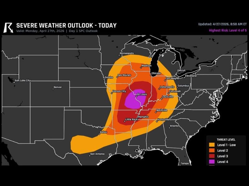
The Storm Prediction Center’s Day 1 outlook has placed the highest risk at Level 4 of 5, with an extreme Level 5 core centered near St. Louis covering portions of central Missouri and southern Illinois. The threat extends broadly across the Midwest from Kansas City and Des Moines eastward through Chicago, Indianapolis, and into western Kentucky and Tennessee.
Level 5 Extreme Risk Core Centered Near St. Louis Signals Catastrophic Potential
The embedded Level 5 Extreme risk zone centered near St. Louis represents the most dangerous designation on the SPC severe weather scale and covers a corridor where the most significant tornado and wind damage outcomes are most likely today. This level of designation is extremely rare and indicates that violent, long-track tornadoes and catastrophic wind events are not just possible but considered probable within the core zone.
Communities in and around St. Louis, southern Illinois, and adjacent portions of Missouri should treat today as a life-threatening weather situation. Residents in the Level 5 zone should already have shelter plans in place and be prepared to take immediate action when warnings are issued.
Level 4 High Risk Covers Broad Area From Kansas City Through Chicago and Indianapolis
Surrounding the extreme core, a Level 4 High Risk zone stretches across a massive footprint covering Kansas City, the Chicago metro, Fort Wayne, Indianapolis, Columbus, Louisville, and Memphis. This level of risk indicates a high probability of multiple significant tornadoes and destructive wind events across a very large geographic area throughout the day and into the evening.
The sheer geographic size of the Level 4 risk area means tens of millions of people are within the highest tiers of today’s severe weather threat. Anyone across this corridor should avoid unnecessary travel and remain indoors with access to weather alerts throughout the afternoon and evening hours.
Multiple Strong Tornadoes and Widespread Wind Damage Expected Across Both States
Multiple strong tornadoes are explicitly listed as likely outcomes today, particularly across Missouri and Illinois where atmospheric parameters are most favorable for violent and long-track storm development. Widespread wind damage is also expected across the broader risk area, meaning destructive conditions could affect communities even outside of direct tornado paths.
The combination of extreme tornado potential and widespread damaging winds creates a scenario where damage could be extensive across a large portion of the Midwest today. Residents are urged to shelter in the lowest interior room of a sturdy structure and stay away from windows when warnings are issued. Stay with NapervilleLocal.com for the latest weather updates and local forecast coverage.

I’ve lived in Naperville long enough to see how quickly our community changes — from new developments downtown to sudden shifts in our Midwest weather. Reporting on Naperville news and daily forecasts gives me the chance to keep neighbors informed about what really matters. My goal is simple: deliver clear, timely updates so you always know what’s happening in our city and what to expect from the skies above.