
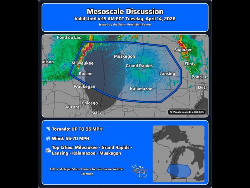
NWS Issues Urgent Mesoscale Discussion for Grand Rapids, Kalamazoo, and Milwaukee as Dangerous Bowing Storm Line Threatens 5 Million With 95 MPH Tornado Risk
GRAND RAPIDS, Mich. — The Storm Prediction Center has issued an urgent mesoscale discussion valid until 4:15 AM EDT Tuesday, covering nearly 5 million people across west Michigan and the surrounding region. A dangerous bowing line segment with damaging winds and an embedded tornado risk is moving onto Lake Michigan, putting Grand Rapids, Kalamazoo, Muskegon, Lansing, and Milwaukee directly in its path. A severe thunderstorm watch extension for the Grand Rapids and Kalamazoo area could be issued within the next hour or two.
Bowing Line Packing 55–70 MPH Destructive Winds
The primary hazard is straight-line wind damage, with gusts of 55 to 70 mph expected with the most intense portions of the line as it moves through the region. These winds are capable of downing trees, snapping power lines, and causing structural damage across the affected corridor.
Residents should secure all outdoor items immediately and avoid parking under trees or near structures that could fail under the force of the incoming gusts.
Embedded Tornadoes Possible Up to 95 MPH
Beyond straight-line winds, embedded tornadoes within the bowing line are possible with top wind speeds reaching up to 95 mph. Tornadoes embedded in fast-moving bow echo systems provide very little warning time — residents across the entire discussion zone should already know their shelter location and be ready to move there instantly upon receiving a warning.
Watch Extension Likely for Grand Rapids and Kalamazoo
Forecasters are signaling that a severe thunderstorm watch extension covering Grand Rapids and Kalamazoo could arrive within the next hour or two. Do not wait for additional alerts — treat the current situation with full urgency right now and take protective action immediately.
Stay with NapervilleLocal.com for the latest weather updates and local forecast coverage.

I’ve lived in Naperville long enough to see how quickly our community changes — from new developments downtown to sudden shifts in our Midwest weather. Reporting on Naperville news and daily forecasts gives me the chance to keep neighbors informed about what really matters. My goal is simple: deliver clear, timely updates so you always know what’s happening in our city and what to expect from the skies above.