
Scattered Showers and Stronger Storm Potential Across Colorado, Southeast Wyoming, Nebraska and Western Kansas This Weekend Before Hotter 80s Next Week
COLORADO — Northwest flow will keep Colorado and nearby areas unsettled through the weekend, with very isolated showers today before more scattered showers and thunderstorms arrive Saturday and Mother’s Day. The best storm chances today stay toward the far northeast plains, western Nebraska, and western Kansas. A few stronger storms are possible Saturday across northeast Colorado into southeast Wyoming and Nebraska before hotter weather builds next week.
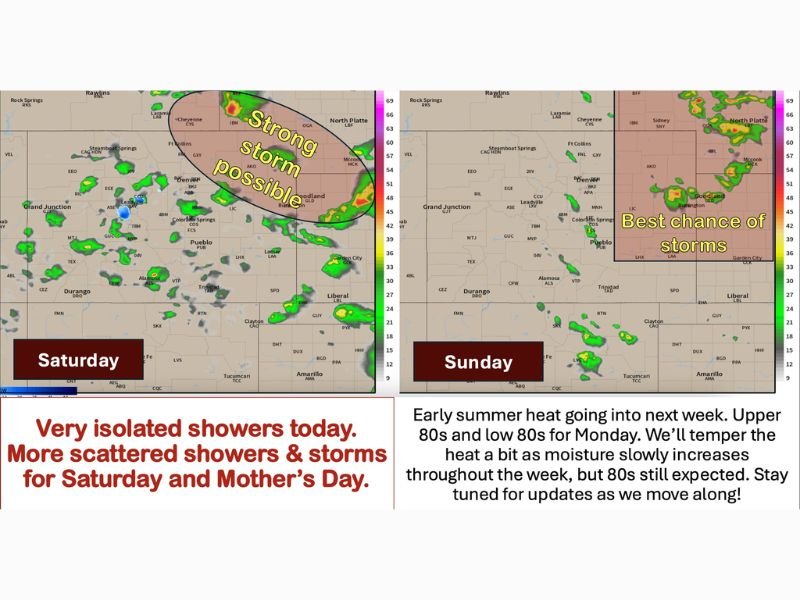
Very Isolated Showers Expected Today Under Northwest Flow
Today’s setup keeps most areas under northwest flow, allowing weak disturbances to move through the region. Showers and storms are expected to stay very isolated, with only limited activity along the Front Range and I-25 corridor.
Temperatures will be mild, with widespread 70s east of the Continental Divide and low to mid 80s on the western slope. The far northeast plains carry the better storm chance, including nearby parts of western Nebraska and western Kansas.
Stronger Storm Potential Increases Saturday
Saturday brings a better chance for scattered showers and thunderstorms as the next disturbance moves through. The map highlights stronger storm potential across northeast Colorado, southeast Wyoming, and into Nebraska.
Temperatures will be similar to Friday, though some areas along and south of Highway 50 and the far eastern plains may climb into the 80s. A couple of stronger thunderstorms cannot be ruled out in the northeastern plains zone.
Mother’s Day Keeps Storm Chances in the Forecast
Storm chances continue into Sunday, though the setup still looks scattered rather than widespread. The best chance for storms remains across the eastern and northeastern side of the region.
Widespread 70s are expected to return Sunday, keeping the day cooler than the early-week heat ahead. Some areas may stay dry, but the forecast still supports at least some shower and thunderstorm risk.
Hotter 80s Build Next Week Before Moisture Returns
By Monday and through much of next week, temperatures are expected to rise into the widespread 80s and near 90 degrees. High pressure should keep conditions mostly dry and hot early in the week.
By midweek, moisture may begin creeping back into Colorado from the south and west. That could bring a few extra clouds first, followed by increasing shower and storm chances later next week. Stay with NapervilleLocal.com for the latest weather updates and local forecast coverage.

I’ve lived in Naperville long enough to see how quickly our community changes — from new developments downtown to sudden shifts in our Midwest weather. Reporting on Naperville news and daily forecasts gives me the chance to keep neighbors informed about what really matters. My goal is simple: deliver clear, timely updates so you always know what’s happening in our city and what to expect from the skies above.