
Scattered Storms and Rainfall Return to Houston and Southeast Texas Friday Into Saturday With Locally Higher Totals Before Hotter Sunny Sunday
HOUSTON, TEXAS — Rain chances return to the Houston area Friday and Saturday after several calmer days, with scattered showers and possibly a few stronger thunderstorms possible. The activity is expected to be hit or miss, meaning not every neighborhood will see the same rainfall. Forecast rainfall totals generally show around 1 inch near Houston, with higher amounts north and east of the metro before hotter, sunnier weather arrives Sunday.
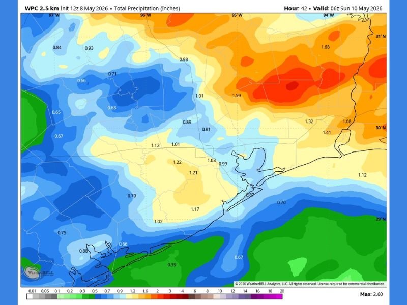
Hit or Miss Storms Return Friday and Saturday
The main change in the forecast is the return of rainfall and thunderstorm potential across the Houston area. Storms are not expected to be widespread everywhere at the same time, but scattered development could affect some areas more than others.
The setup also carries a chance for a few stronger thunderstorms. While the data does not show a widespread severe outbreak, the wording suggests storms are worth watching during the Friday and Saturday period.
Rainfall Totals Near Houston Mostly Around 1 Inch
The rainfall map shows much of the Houston area near the 1-inch range through early Sunday. Values around the metro appear close to 0.99 to 1.03 inches, with nearby coastal and inland spots varying slightly.
Some surrounding areas could see less, especially closer to the coast and offshore zones where totals appear closer to 0.67 to 0.87 inches. This supports the hit-or-miss nature of the expected rainfall.
Higher Rainfall Signal North and East of Houston
The heaviest rainfall signal appears north and east of Houston, where mapped totals climb higher than the metro. Some areas show totals around 1.32 to 1.68 inches, especially farther northeast.
That means communities outside the core Houston area may have a better chance of seeing heavier downpours. Localized rainfall differences could be noticeable from one area to another.
Hotter and Sunnier Conditions Expected Sunday
After the Friday and Saturday rain window, Sunday is expected to turn hotter and sunnier. This marks a shift away from scattered storm chances and back toward a brighter, warmer pattern.
A slightly cooler start to next week is also expected after Sunday’s heat. For now, the main weather focus remains the return of scattered rainfall and stronger storm potential before the weekend pattern changes. Stay with NapervilleLocal.com for the latest weather updates and local forecast coverage.

I’ve lived in Naperville long enough to see how quickly our community changes — from new developments downtown to sudden shifts in our Midwest weather. Reporting on Naperville news and daily forecasts gives me the chance to keep neighbors informed about what really matters. My goal is simple: deliver clear, timely updates so you always know what’s happening in our city and what to expect from the skies above.