
Scattered Showers and Thunder Possible With Humid 70s and 80s Across Arkansas Including Little Rock, Fort Smith, and Texarkana With Higher Storm Chances Returning Saturday
ARKANSAS — A warm and humid Friday is in store across Arkansas with high temperatures climbing into the 70s and 80s statewide, accompanied by scattered shower and thunder chances that will remain possible through the day. Overnight showers have already been observed across portions of the state, and that scattered activity is expected to continue into the afternoon hours with wind gusts staying very low at less than 10 mph for most of the state. Storm chances increase further heading into Saturday, making this a two-day period that warrants continued weather awareness across the region.
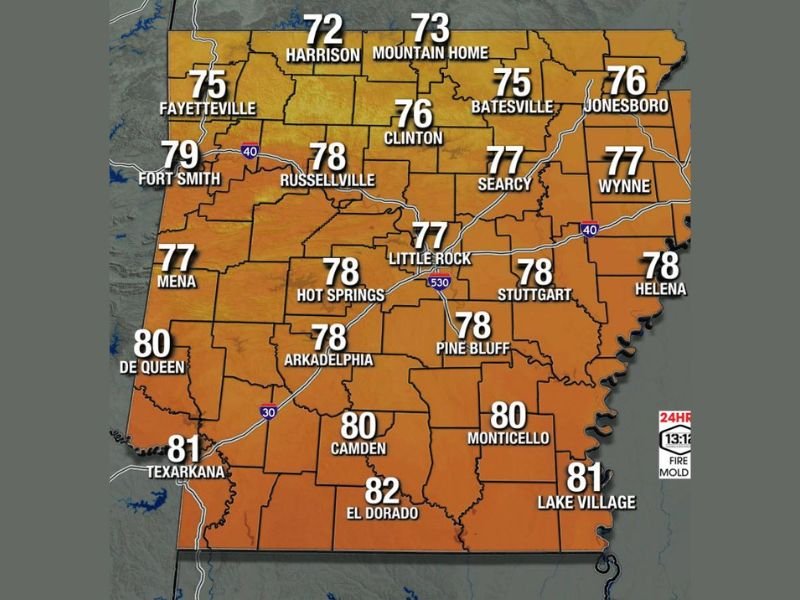
Statewide Highs Climbing Into the Warm 70s and Low 80s With Noticeable Humidity Friday
Temperatures across Arkansas on Friday will be warm and humid, with the majority of the state topping out in the upper 70s. Northern communities including Harrison and Mountain Home will see the coolest readings at 72 and 73 degrees respectively, while Fayetteville reaches 75 and Fort Smith climbs to 79.
Central Arkansas sits comfortably in the upper 70s, with Little Rock forecast at 77 degrees, Russellville at 78, and Hot Springs also reaching 78. Southern Arkansas will see the warmest readings of the day, with El Dorado topping out at 82, Texarkana reaching 81, Lake Village at 81, and Camden and Monticello both hitting 80 degrees.
Scattered Showers and Thunder Chances Persist Through Friday After Overnight Activity
Scattered shower and thunder chances will remain active across Arkansas through Friday following overnight shower activity already observed across portions of the state. The storm coverage is not expected to be widespread or organized, but isolated cells capable of brief heavy rain and thunder can develop at any point through the afternoon hours.
Wind gusts across the vast majority of the state will remain very low and under 10 mph through the day, keeping conditions relatively calm between any storm activity. The combination of warmth, humidity, and lingering moisture support is enough to keep scattered rain and thunder in the forecast picture through the evening.
Higher Rain and Storm Chances Return Saturday Keeping Arkansas on Alert This Weekend
The unsettled pattern building into the weekend brings higher rain and storm chances back to Arkansas on Saturday, raising the threat level above what is expected on Friday. Residents across the state should be prepared for a more active storm day Saturday compared to the scattered and isolated nature of Friday’s activity.
Staying connected to local forecasts through the end of the week is strongly recommended as Saturday’s storm setup comes into sharper focus. Anyone with outdoor plans for the weekend should monitor conditions closely and have a weather contingency plan in place before Saturday arrives.
Stay with NapervilleLocal.com for the latest weather updates and local forecast coverage.

I’ve lived in Naperville long enough to see how quickly our community changes — from new developments downtown to sudden shifts in our Midwest weather. Reporting on Naperville news and daily forecasts gives me the chance to keep neighbors informed about what really matters. My goal is simple: deliver clear, timely updates so you always know what’s happening in our city and what to expect from the skies above.