
Scattered Storms With Heavy Rain and Gusty Winds Threaten North Carolina Including Raleigh, Charlotte, and Winston-Salem This Afternoon
NORTH CAROLINA — A double weather threat is developing across North Carolina today and continuing into Friday morning, as a cold front from the northwest approaches while the remnants of post-Tropical Storm Arthur move in from the south. These two systems combining will spark scattered showers and thunderstorms this afternoon and evening, with the best storm chances north and west across the state. Overnight into Friday morning, Arthur’s remnants will spread rain and possibly storms across Eastern and Southeastern North Carolina, with a limited severe weather risk possible Friday morning.
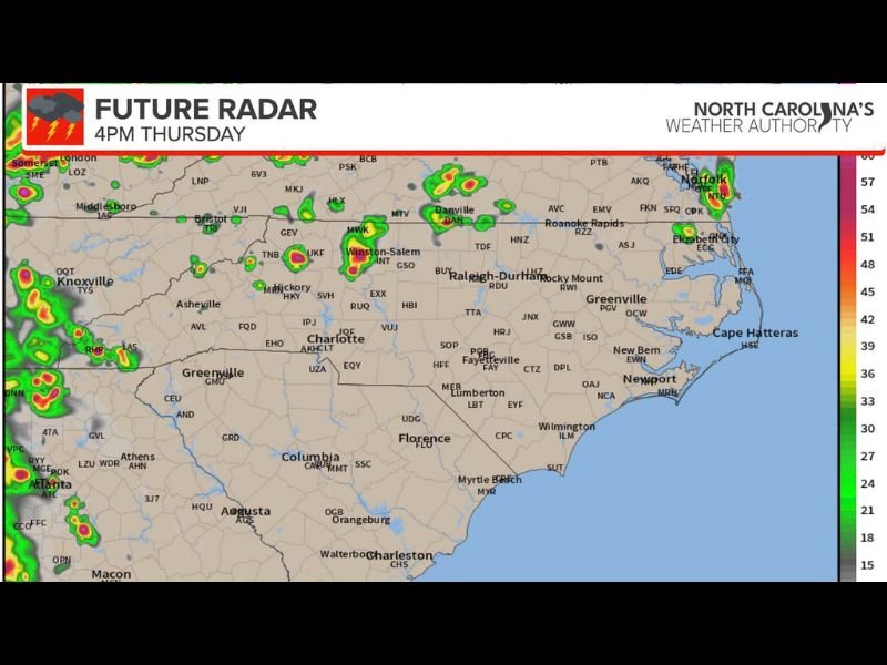
Best Storm Chances North and West This Afternoon and Evening
The future radar for Thursday afternoon shows the most concentrated storm activity developing across the northern and western portions of North Carolina, including the Winston-Salem, Raleigh-Durham, Danville, and Roanoke Rapids corridors. Charlotte and the Piedmont region also fall within the storm coverage zone through the afternoon and into the overnight hours.
The main threats with any storm that develops this afternoon and into the overnight hours are bursts of heavy rainfall and gusty winds. An isolated severe storm with damaging winds cannot be ruled out, though widespread severe weather is not anticipated for today’s round.
Arthur Remnants Spread Rain Into Eastern and Southeastern NC Friday Morning
Overnight Thursday into Friday morning, the remains of Arthur will move into North Carolina from the south, spreading rain and possibly some storms across the eastern portions of the state. A limited risk of severe weather exists Friday morning across parts of Eastern and Southeastern North Carolina as these remnants interact with the broader pattern.
Future radar imagery through midnight Thursday shows active storm coverage across Charlotte, Fayetteville, Wilmington, Greenville, New Bern, and the Cape Hatteras corridor during the overnight window.
Friday Morning Plans Should Account for Scattered Rain
Anyone with outdoor plans Friday morning across Eastern and Southeastern North Carolina should be prepared for scattered rain and plan accordingly. The storm coverage and timing could shift as Arthur’s remnants move through the state.
Stay with NapervilleLocal.com for the latest weather updates and local forecast coverage.

I’ve lived in Naperville long enough to see how quickly our community changes — from new developments downtown to sudden shifts in our Midwest weather. Reporting on Naperville news and daily forecasts gives me the chance to keep neighbors informed about what really matters. My goal is simple: deliver clear, timely updates so you always know what’s happening in our city and what to expect from the skies above.