
Tornado Warning Issued Near Ithaca and Taughannock Falls New York as Tornado-Capable Storm Races East at 50 MPH Toward Cortland and Syracuse — Take Shelter Now
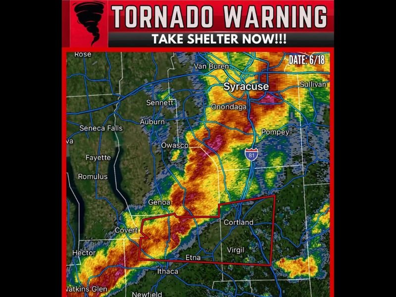
NEW YORK — A Tornado Warning is in effect for central New York as a severe thunderstorm capable of producing a tornado was located near Taughannock Falls and Ithaca, moving east at 50 mph. The warning polygon shown on radar covers a defined zone encompassing Cortland, Etna, Virgil, Covert, and Genoa, with the fast-moving storm threatening to bring tornado conditions to communities in its path within minutes. Anyone in or near the warning polygon must take shelter immediately without delay.
Fast-Moving Storm Threatens Cortland and Surrounding Communities
At 50 mph, this storm is moving at a very fast pace, meaning communities in its path have very little time to take shelter from the moment a warning is received. The warned storm was located near Taughannock Falls and Ithaca at the time of issuance, with its track pointing directly toward Cortland, Etna, and Virgil based on the warning polygon displayed on radar.
The radar imagery shows deep red and orange returns within the warning polygon with embedded pink rotation signatures, consistent with a storm capable of producing a tornado. Syracuse and surrounding areas to the northeast should remain on high alert as this storm continues its rapid eastward track.
Take Shelter in an Interior Room on the Lowest Floor Immediately
This is an active Tornado Warning. There is no time to wait for confirmation of a visible funnel or the sound of a tornado before taking action. Move to the lowest floor of a sturdy building and go to an interior room away from all windows immediately.
Do not attempt to outrun this storm by vehicle given its 50 mph forward speed. If you are in a mobile home or vehicle, abandon it immediately and seek the nearest permanent structure or lie flat in a low-lying area away from trees.
Monitor for Additional Warnings as Storm Tracks Northeast Toward Syracuse
With the storm tracking northeast at 50 mph, communities including Auburn, Onondaga, Pompey, and the greater Syracuse area should monitor conditions extremely closely. Additional warnings may be issued rapidly as this storm continues its fast-moving track.
Stay with NapervilleLocal.com for the latest weather updates and local forecast coverage.

I’ve lived in Naperville long enough to see how quickly our community changes — from new developments downtown to sudden shifts in our Midwest weather. Reporting on Naperville news and daily forecasts gives me the chance to keep neighbors informed about what really matters. My goal is simple: deliver clear, timely updates so you always know what’s happening in our city and what to expect from the skies above.