
Several Days of Flooding Rain Threaten the Western and Upper Gulf Coast From Texas to Alabama With Moderate Flash Flood Risk Shifting East Monday Through Thursday
GULF COAST — A multi-day flooding rain threat is developing across the western and upper Gulf Coast region, driven by a lingering frontal line mixing with rich tropical moisture. Some model runs are showing potential for double-digit rainfall totals in localized areas as this pattern unfolds through the week. Forecasters are also watching for a low pressure system to possibly attach to this setup later in the week, which would further increase storm chances and rainfall potential.
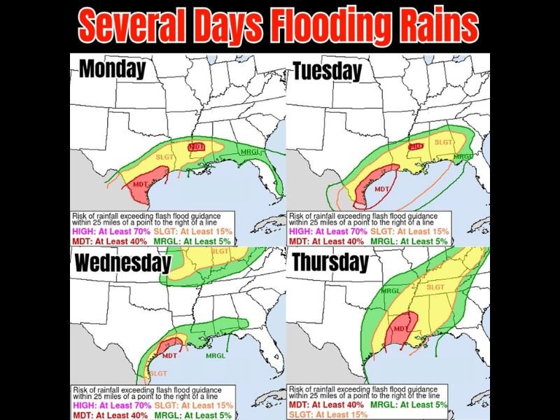
Monday and Tuesday Bring Moderate Flood Risk to Texas and Louisiana Coast
Monday’s flash flood risk shows a Moderate Risk zone, indicating at least a 40% chance of rainfall exceeding flash flood guidance, stretching along the Texas Gulf Coast and extending toward southwest Louisiana. A broader Slight Risk and Marginal Risk zone covers a wide swath from the Texas coast eastward across the Gulf region.
By Tuesday, the Moderate Risk zone shifts eastward, now centered closer to the Louisiana and Mississippi coastline, with the Slight and Marginal Risk zones extending across a large portion of the central Gulf Coast and into the Florida Panhandle.
Wednesday and Thursday Track Eastward Toward Mississippi and Alabama
Wednesday’s Moderate Risk zone continues its eastward progression, now positioned along the Louisiana and Mississippi coastline with Slight and Marginal Risk extending across Alabama and into the Florida Panhandle.
By Thursday, the Moderate Risk zone has moved further east toward the Alabama and Florida Panhandle coastline, with the Slight and Marginal Risk zones now covering a broad area extending northward through Mississippi, Alabama, Georgia, and into the Carolinas.
Low Pressure System Could Increase Storm Chances Later This Week
The progression of this flooding rain threat across multiple days reflects a slow-moving frontal boundary continuing to tap into tropical moisture. If a low pressure system attaches to this setup as some guidance suggests, storm chances and rainfall totals could increase further later in the week.
Residents across the Gulf Coast region should monitor local flood guidance closely as this multi-day event unfolds. Stay with NapervilleLocal.com for the latest weather updates and local forecast coverage.

I’ve lived in Naperville long enough to see how quickly our community changes — from new developments downtown to sudden shifts in our Midwest weather. Reporting on Naperville news and daily forecasts gives me the chance to keep neighbors informed about what really matters. My goal is simple: deliver clear, timely updates so you always know what’s happening in our city and what to expect from the skies above.