
Severe Storms and Strong Wind Shear Targeting Alabama Wednesday Night Into Early Thursday as Powerful Rocky Mountain System Builds With Dangerous Instability and Gulf Moisture
ALABAMA — The Storm Prediction Center is actively monitoring a powerful weather system moving out of the Rockies that is expected to bring a round of severe storms to Alabama during the Wednesday night into early Thursday morning window. Conditions are currently quiet, but confidence is increasing that the main ingredients for severe weather — atmospheric instability and strong wind shear — will be in place by midweek. A surge of warm and sticky Gulf air pushing north by Wednesday will serve as the primary fuel source for storm development across the state.
Gulf Moisture Surging North by Wednesday Sets the Stage for Severe Storm Fuel
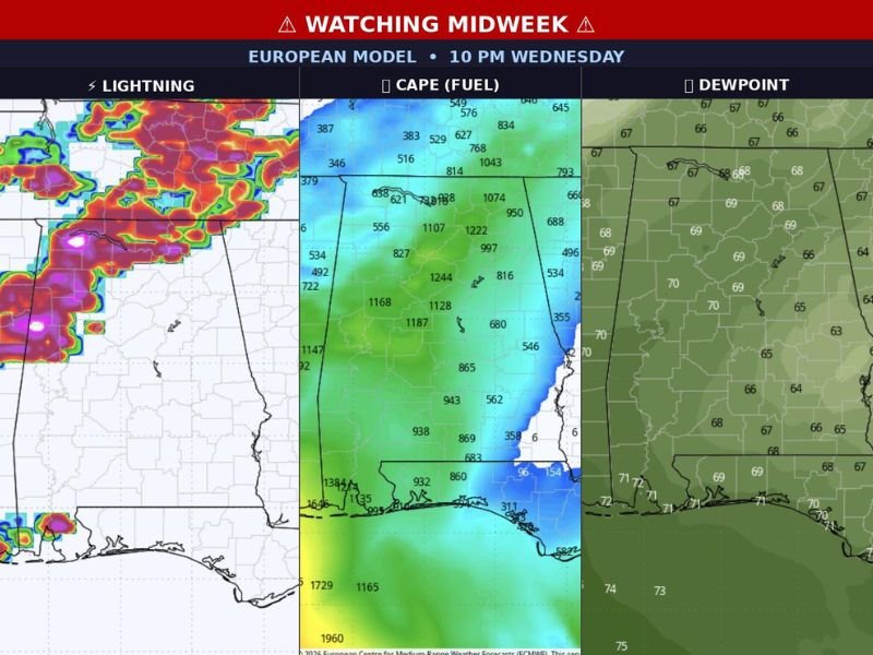
A surge of warm and moist air from the Gulf of Mexico is forecast to push northward into Alabama by Wednesday, dramatically destabilizing the atmosphere and loading the environment with storm fuel. European model data for 10 PM Wednesday is already showing significant CAPE values exceeding 1,000 to 1,200 across central and northern Alabama, indicating a highly unstable air mass capable of supporting intense thunderstorm development.
Dewpoint values shown on model data are running in the upper 60s to near 70 degrees across the southern and central portions of the state, confirming the depth and richness of the moisture layer that will be in place ahead of the arriving system. This combination of instability and moisture creates a dangerous severe weather environment when strong wind shear is also present.
Wednesday Night Into Thursday Morning Identified as Primary Severe Weather Window
Tuesday’s Day 4 severe weather action is expected to remain primarily to the west across Oklahoma and Arkansas, keeping Alabama out of the most immediate threat through that period. The system then shifts directly into Alabama’s zone on Wednesday, with the primary impact window running from Wednesday evening through early Thursday morning based on current model timing.
The European model lightning data for 10 PM Wednesday shows intense storm activity already well organized across the region at that hour, suggesting the severe weather window could be both significant and fast-moving once it arrives. Exact timing details remain somewhat uncertain but are expected to come into sharper focus as the week progresses.
Residents Urged to Activate Weather Alerts and Identify Safe Locations Now
With confidence increasing for a meaningful severe weather event, Alabama residents are urged to take preparedness steps immediately rather than waiting for the system to arrive. Ensuring weather alert notifications are active on all devices and identifying a safe shelter location inside the home should be completed well ahead of Wednesday evening.
Staying tuned for updates through Monday and Tuesday will be critical as forecast confidence and timing details improve with each model run through the week.
Stay with NapervilleLocal.com for the latest weather updates and local forecast coverage.

I’ve lived in Naperville long enough to see how quickly our community changes — from new developments downtown to sudden shifts in our Midwest weather. Reporting on Naperville news and daily forecasts gives me the chance to keep neighbors informed about what really matters. My goal is simple: deliver clear, timely updates so you always know what’s happening in our city and what to expect from the skies above.