
EF-2 Tornadoes, 2-Inch Hail, and 80 MPH Winds Threatening Iowa, Missouri, and Oklahoma Thursday April 23 With All Modes of Severe Weather Possible
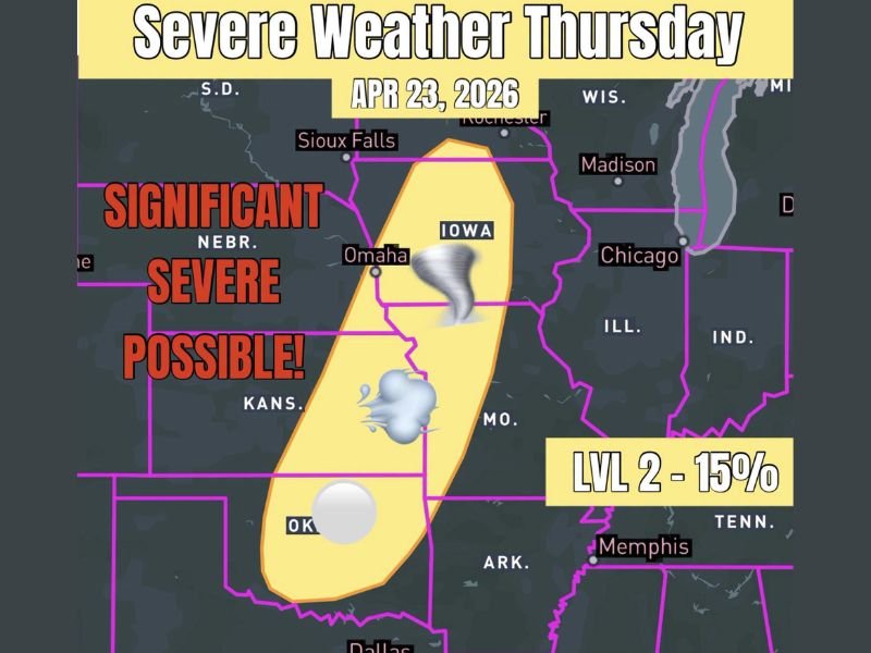
IOWA, MISSOURI, AND OKLAHOMA — Thursday April 23, 2026 is shaping up as the next significant severe weather day across a broad corridor stretching from southern Minnesota southward through Iowa, Missouri, Kansas, and into Oklahoma.
All modes of severe weather are possible across this zone, with significant severe weather specifically flagged including strong EF-2 tornadoes, hail over 2 inches in diameter, and wind gusts exceeding 80 MPH. The risk area has been expanding northward each day, now reaching as far as southern Minnesota while simultaneously extending southward into Oklahoma.
Significant Severe Weather Corridor Covers Iowa Through Oklahoma
The Thursday severe weather outlook map places a Level 2 risk zone with a 15% probability of severe weather within 25 miles of any point across the outlined corridor. The risk zone is centered across Iowa and Missouri, extending northward toward Sioux Falls and southward through Kansas and into Oklahoma.
The significant severe designation within this corridor means the potential hazards go beyond garden-variety severe weather. EF-2 strength tornadoes, hail larger than 2 inches, and wind gusts over 80 MPH are all explicitly highlighted as possible outcomes with Thursday’s storm setup, placing this event in a higher-end category of severe weather concern.
Risk Area Expanding Northward Into Southern Minnesota
One of the notable and concerning trends with Thursday’s developing setup is the northward expansion of the risk area with each passing day. The threat zone has now extended as far north as southern Minnesota, incorporating areas near Rochester and Sioux Falls into the severe weather corridor that was previously focused further south.
This northward expansion indicates that the atmospheric ingredients supporting severe weather development are becoming established across a larger geographic area than initially anticipated, which increases the geographic scope of Thursday’s potential impacts.
EF-2 Tornadoes Represent the Most Significant Threat
Among the three hazards highlighted for Thursday, strong EF-2 tornadoes represent the most life-threatening concern for residents across the risk corridor. EF-2 tornadoes produce winds of 111 to 135 MPH and are capable of causing considerable damage to well-constructed homes, uprooting large trees, and destroying mobile homes and outbuildings completely.
The broad corridor from southern Minnesota through Iowa, Missouri, Kansas, and Oklahoma means that millions of residents across multiple states need to have tornado safety plans finalized well before Thursday afternoon arrives.
Prepare Now for Thursday’s Developing Threat
With Thursday still several days away, residents across Iowa, Missouri, Kansas, Oklahoma, and surrounding states have valuable time to prepare properly. Ensure weather alert systems are active and functioning, identify interior shelter locations on the lowest floor of sturdy buildings, and stay tuned to updated forecasts as Thursday’s setup continues to come into sharper focus through the week. Stay with NapervilleLocal.com for the latest weather updates and local forecast coverage.

I’ve lived in Naperville long enough to see how quickly our community changes — from new developments downtown to sudden shifts in our Midwest weather. Reporting on Naperville news and daily forecasts gives me the chance to keep neighbors informed about what really matters. My goal is simple: deliver clear, timely updates so you always know what’s happening in our city and what to expect from the skies above.