
Warmer and Windy Conditions Build Across Colorado With Storms Possible South of I-70 Near Pueblo and Trinidad Today as Dangerous Heat Builds Toward Wednesday
COLORADO — Temperatures are turning noticeably warmer across Colorado and the surrounding region this Monday, June 15, with windy conditions also developing depending on location. While not everyone gets in on the action, the best chances for showers and thunderstorms today are focused across the mountains south of I-70 and portions of southeast Colorado, while northern Colorado and southeast Wyoming remain largely dry. The bigger story continues to be a significant heat ramp-up building toward midweek.
Today’s Highs Range From 68° in the Mountains to 94° on the Western Slope
SE Wyoming and the I-80 Corridor are forecast for 70 to 82°F today, with the Foothills, Front Range, and I-25 Corridor reaching 75 to 86°F. Colorado Mountain Valleys are running 68 to 84°F, with considerably cooler conditions at higher elevations.
The Western Slope is the warmest zone today at 80 to 94°F, while the Eastern Plains, western Nebraska, and western Kansas are forecast for 78 to 88°F. Windy conditions are expected across multiple zones, so secure any lightweight outdoor items.
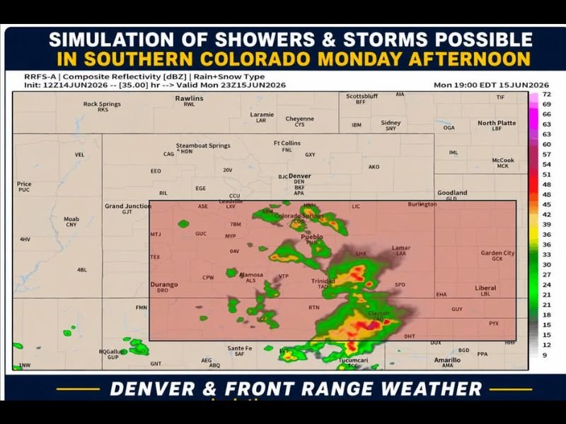
Storms Focus on Southern Colorado Including Pueblo and Trinidad This Afternoon
The simulation valid for Monday at 7 PM EDT shows the highest storm activity developing across southern Colorado, with notable cells near Colorado Springs, Pueblo, Alamosa, Trinidad, and extending toward Clayton and Tucumcari. This activity aligns with the mountains south of I-70 and southeast Colorado, where the best chances for showers and thunderstorms exist today.
Northern Colorado, southeast Wyoming, and areas farther north and east should remain largely dry through the afternoon and evening.
Heat Ramps Up Sharply Toward Wednesday’s Triple Digit Potential
After a warmer Tuesday, Wednesday looks downright hot with widespread 90s likely and some eastern plains locations potentially reaching triple digits. A front brings temperatures back into the 80s Thursday, except on the Western Slope which stays consistently hot, before another warm-up returns 90s by Friday into Saturday.
Stay with NapervilleLocal.com for the latest weather updates and local forecast coverage.

I’ve lived in Naperville long enough to see how quickly our community changes — from new developments downtown to sudden shifts in our Midwest weather. Reporting on Naperville news and daily forecasts gives me the chance to keep neighbors informed about what really matters. My goal is simple: deliver clear, timely updates so you always know what’s happening in our city and what to expect from the skies above.