
Stronger Storms and Damaging Wind Gusts Up to 51 MPH Targeting Alabama Including Birmingham, Shelby County, and Montgomery Along Critical Boundary Tuesday Evening
ALABAMA — A critical weather boundary is setting up between Birmingham and Montgomery this Tuesday evening, April 28, 2026, creating a focused zone where stronger storms are most likely to develop and intensify later today. Morning storm activity has dropped rain-cooled air across North and Central Alabama, establishing a boundary that acts similarly to a mini cold front and serves as a focal point for storm development and intensification through the evening hours. Peak wind gusts up to 51 miles per hour are forecast through 11 PM Tuesday across portions of the affected area.
Rain-Cooled Boundary Between Birmingham and Montgomery Is the Key Focus Tonight
The boundary established by this morning’s storm activity across North and Central Alabama is the single most important factor in tonight’s severe weather setup. Storms consistently lock onto these types of boundaries and use them as a source of fuel for rapid growth and intensification, making the corridor between Birmingham and Montgomery the highest-priority area to watch through the evening hours.
Residents in the Birmingham metro, Shelby County, and communities tracking toward Montgomery should treat this evening as an active weather situation requiring close attention. The boundary setup creates the potential for storms to strengthen quickly as they interact with the temperature and moisture contrast along this zone.
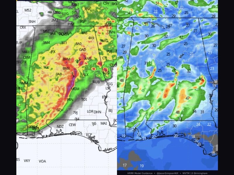
Peak Wind Gusts Reaching 51 MPH Forecast Through 11 PM Across Affected Areas
Wind gust forecasts through 11 PM Tuesday show peak values reaching 51 miles per hour across portions of the affected region, with widespread gusts in the 30 to 42 mile per hour range extending across a broad area of Alabama. These wind speeds are capable of downing trees, snapping power lines, and causing property damage across communities in the path of stronger storm cells.
The wind threat is not isolated to a single narrow corridor but extends across much of the central Alabama region as storm clusters and individual cells interact with the boundary through the evening. Residents should secure any loose outdoor items before evening storms develop and be prepared for potential power disruptions through the overnight hours.
Birmingham Metro and Shelby County Face the Highest Storm Intensity Risk Tonight
The Birmingham metropolitan area and Shelby County sit directly along the boundary zone identified as the focal point for tonight’s storm development, placing these communities at the highest risk for encountering the strongest storm activity of the evening. Storms that develop along or interact with this boundary will have access to enhanced instability and wind shear that can support rapid intensification.
Anyone in the Birmingham metro, Shelby County, or communities between Birmingham and Montgomery should keep weather alerts active through 11 PM tonight and be ready to take shelter immediately if warnings are issued for their area. Tonight’s setup is localized but capable of producing impactful conditions quickly. Stay with NapervilleLocal.com for the latest weather updates and local forecast coverage.

Naperville is a community with stories that deserve to be told — both the serious ones about safety and justice, and the lighter ones that capture our culture and daily life. I focus on covering crime reports and court updates while also highlighting the traditions, events, and social trends that shape who we are. Through my reporting, I want to give readers a fuller picture of Naperville — the challenges we face and the character that keeps our city strong.