
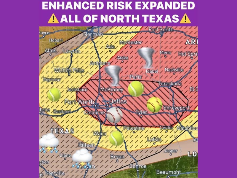
Very Large Hail Up to 4 Inches, Tornadoes, and 70 MPH Winds Targeting North Texas Including Dallas, Fort Worth, and McKinney With Enhanced Risk Expanded
NORTH TEXAS — The Enhanced Risk has been expanded this morning to cover all of North Texas, placing the entire region under a significant severe weather threat today, Tuesday, April 28, 2026. Very large hail up to 4 inches in diameter is the primary hazard, with a couple of tornadoes possible and wind gusts reaching 70 miles per hour across the affected area. The main severe weather window runs from 4 PM to 9 PM, though storms near Wichita Falls under a Severe Watch could begin moving into the Dallas-Fort Worth metroplex as early as noon based on the newest available data.
Very Large Hail Up to 4 Inches Is the Headline Threat Across North Texas Today
The dominant hazard with today’s severe weather setup is very large hail, with the potential for stones up to 4 inches in diameter across the core of the Enhanced Risk zone covering Dallas, Fort Worth, McKinney, and surrounding communities. Hail imagery on the outlook map shows a progression from tennis ball to softball to baseball size across the North Texas corridor, reflecting the extreme hail production potential with today’s supercell environment.
Hail of this magnitude causes catastrophic and irreversible damage to vehicles, destroys roofing materials, shatters windows, and can injure or kill livestock and pets left outdoors. All vehicles must be moved to covered parking before afternoon storms develop, and residents should stay indoors when any storm with large hail approaches their location.
Early Storm Threat Possible Near Wichita Falls Moving Into Metroplex Around Noon
Storms currently developing near Wichita Falls under an active Severe Watch may break off early and begin moving southeast later this morning. The newest data suggests some of these storms could push into the Dallas-Fort Worth metroplex area around noon, several hours ahead of the main 4 to 9 PM severe weather window.
Residents across the northern metroplex communities should remain weather aware through the late morning hours and not assume the threat is limited to the afternoon. Any storm breaking through early could still carry significant hail and wind potential given the atmospheric energy already in place across the region.
Tornadoes and 70 MPH Winds Round Out the Hazard Profile Across the Enhanced Zone
A couple of tornadoes are possible within today’s Enhanced Risk zone, particularly where supercells can maintain discrete storm mode ahead of storm consolidation into clusters or lines. Wind gusts reaching 70 miles per hour add a widespread damaging wind component to today’s hazard profile, extending the threat to communities even outside direct hail or tornado impact zones.
The combination of extreme hail, tornado potential, and damaging winds makes today one of the more significant severe weather days for North Texas in recent weeks. Multiple ways to receive warnings should be active for all residents across the Dallas, Fort Worth, McKinney, Tyler, and Shreveport corridors through the evening hours. Stay with NapervilleLocal.com for the latest weather updates and local forecast coverage.

Naperville is a community with stories that deserve to be told — both the serious ones about safety and justice, and the lighter ones that capture our culture and daily life. I focus on covering crime reports and court updates while also highlighting the traditions, events, and social trends that shape who we are. Through my reporting, I want to give readers a fuller picture of Naperville — the challenges we face and the character that keeps our city strong.