
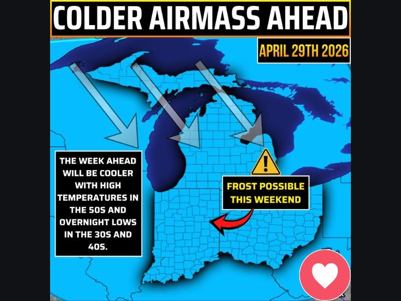
Widespread Frost Risk and Cold Airmass Settling Across Indiana With Highs in the 50s and Lows in the 30s Through the Weekend Before Warmup Next Week
INDIANA — A cold airmass has arrived and is here to stay across Indiana through the week, bringing high temperatures locked in the 50s and overnight lows dipping into the 30s and 40s for much of the state. The most significant concern with this pattern is the weekend frost risk, as forecast models are showing low temperatures dropping into the low 30s on both Saturday and Sunday nights, which could lead to widespread frost conditions across Indiana. Temperatures are not expected to recover back into the 60s and potentially the 70s until next Monday.
Highs Staying in the 50s All Week With Overnight Lows Dropping Into the 30s and 40s
The cold airmass pushing down from the north will keep daytime high temperatures well below seasonal norms across Indiana through the entire week, with highs holding in the 50s statewide through the weekend period. This represents a noticeable and sustained departure from the warm and active weather pattern that has dominated the region in recent days.
Overnight lows will drop into the 30s and 40s across much of Indiana through the week, creating chilly morning conditions that will feel more like early March than late April. Residents should prepare for a prolonged stretch of cool and below-normal temperatures before any meaningful warmup returns to the region heading into next week.
Widespread Frost Risk Possible Saturday and Sunday Nights Across Indiana
The most impactful aspect of this week’s cold pattern is the frost risk developing for Saturday and Sunday nights, when forecast models are showing low temperatures dropping into the low 30s across much of Indiana. Widespread frost at this time of year can damage or kill tender vegetation, early garden plants, and recently emerged crops that have not yet hardened off to cold conditions.
Gardeners and agricultural interests across Indiana should monitor Saturday and Sunday night forecast lows closely as the weekend approaches. Covering sensitive plants, moving potted vegetation indoors, and taking precautions for frost-sensitive crops before Saturday night will be important steps for anyone with outdoor growing interests across the state.
Temperatures Return to the 60s and Possibly 70s by Next Monday
After enduring a full week of below-normal temperatures and the weekend frost threat, Indiana will finally see a return to more seasonable conditions beginning next Monday. Temperatures are expected to climb back into the 60s and potentially reach the 70s as the cold airmass retreats and a warmer pattern begins to establish itself across the region.
The recovery back to more typical late April and early May temperatures next week will be a welcome change after what will have been a prolonged cold stretch for Indiana. Residents can look forward to a moderating trend beginning next Monday after getting through the coldest portion of the pattern this weekend. Stay with NapervilleLocal.com for the latest weather updates and local forecast coverage.

I’ve lived in Naperville long enough to see how quickly our community changes — from new developments downtown to sudden shifts in our Midwest weather. Reporting on Naperville news and daily forecasts gives me the chance to keep neighbors informed about what really matters. My goal is simple: deliver clear, timely updates so you always know what’s happening in our city and what to expect from the skies above.