
Supercell Tornado Threat With Very Large Hail and Damaging Winds Targeting Eastern Colorado and Western Kansas Including Fort Morgan, Hays, and Garden City Monday June 1
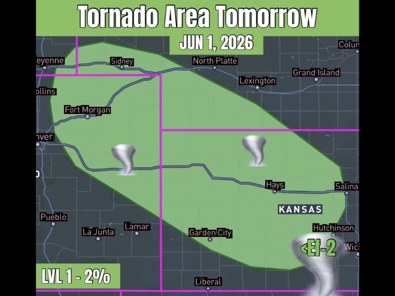
EASTERN COLORADO AND WESTERN KANSAS — A tornado threat returns to eastern Colorado and western Kansas on Monday, June 1, 2026, as the next ripple of energy moves into the region and supercells are once again likely to develop across the corridor. The setup currently carries a Level 1 designation with a 2 percent tornado probability and less than EF-2 tornado potential, but forecasters are watching for a possible upgrade to Level 2 given expected storm coverage as the event develops through the day.
Supercells Likely to Develop Again Across Eastern Colorado and Western Kansas Monday
The next shortwave energy ripple moving into the region will provide the trigger needed for supercell development across the eastern Colorado and western Kansas corridor on Monday. The risk zone covers a broad area from near Sidney and Fort Morgan in northeastern Colorado southeastward through Lamar, Garden City, Hays, and toward Hutchinson and Salina in central Kansas.
Very large hail and damaging wind gusts will accompany the tornado threat as the primary severe weather hazards across the entire risk zone. Any supercell that develops Monday will have access to sufficient shear and instability to support organized and dangerous storm structures through the afternoon and evening.
Level 1 Risk Currently in Place With Upgrade to Level 2 Possible Before the Event
The current Level 1 tornado risk designation could be upgraded to Level 2 before Monday’s event unfolds given the expected storm coverage and supercell potential across the corridor. Residents should not wait for an upgrade before beginning preparations, as the Level 1 risk alone is sufficient to warrant a shelter plan and weather awareness through the day.
The less than EF-2 tornado probability reflects a real but lower-end intensity ceiling for any tornado that does develop, though even an EF-1 tornado can cause significant damage and pose a life-threatening risk to anyone in its direct path.
Eastern Colorado Through Central Kansas Needs Full Severe Weather Preparedness Monday
All communities within the risk zone from Fort Morgan and Lamar through Garden City, Hays, and Salina should have a shelter plan ready and stay closely connected to local severe weather alerts through Monday afternoon and evening as storm development unfolds. Stay with NapervilleLocal.com for the latest weather updates and local forecast coverage.

I’ve lived in Naperville long enough to see how quickly our community changes — from new developments downtown to sudden shifts in our Midwest weather. Reporting on Naperville news and daily forecasts gives me the chance to keep neighbors informed about what really matters. My goal is simple: deliver clear, timely updates so you always know what’s happening in our city and what to expect from the skies above.