
TORCON 4 Tornado Threat Targets Indianapolis, St Louis, Louisville and Springfield Father’s Day With Large Destructive Hail and Damaging Winds
INDIANAPOLIS — A Father’s Day severe weather outbreak is underway across the Ohio Valley and Midwest, with a TORCON 4 rating signaling an elevated risk of strong tornadoes today. A cold front draping from the Ohio Valley back into the Texas Panhandle is expected to fuel a few strong tornadoes, large hail, and very gusty winds. The highest threat zone covers Indianapolis, Evansville, Louisville, St. Louis, Springfield, and Joplin. Storms are already developing this morning across Iowa, Kansas, and Missouri before reintensifying and pushing east through the afternoon.
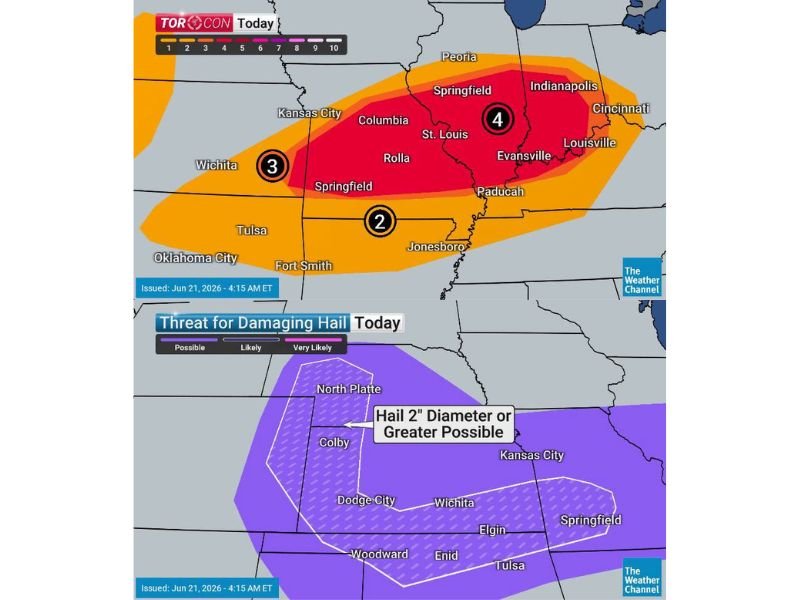
TORCON 4 Zone Stretches From Missouri Into Ohio Valley
The core TORCON 4 risk area extends from Columbia and St. Louis through Springfield, Indianapolis, Evansville, and Louisville, where conditions are most favorable for strong, long-track tornadoes. A TORCON 3 risk covers Wichita and Kansas City, while a TORCON 2 extends south toward Springfield, Missouri, Tulsa, and Fort Smith.
Large Destructive Hail Threat Spans Illinois to Colorado
A widespread hail threat stretches from Illinois back to Colorado, with hailstones reaching two inches in diameter or larger possible in the most intense storms. The greatest risk for destructive hail extends from North Platte and Colby through Dodge City, Wichita, and Enid, where residents are urged to park vehicles in a garage if possible.
Morning Storms Set Stage for Afternoon Reintensification
Storms moving through Iowa, Kansas, and Missouri this morning are expected to weaken temporarily before reintensifying by late afternoon as they track east. This second wave is forecast to bring the greatest tornado and severe wind threat to the Ohio Valley region later today.
Damaging Winds Add to Multi-Hazard Setup
In addition to tornadoes and hail, very gusty and potentially damaging winds are expected with the strongest storms, particularly along the TORCON 4 corridor. Residents across the affected region are encouraged to have a way to receive warnings and a safety plan ready throughout the day.
Stay with NapervilleLocal.com for the latest weather updates and local forecast coverage.

I’ve lived in Naperville long enough to see how quickly our community changes — from new developments downtown to sudden shifts in our Midwest weather. Reporting on Naperville news and daily forecasts gives me the chance to keep neighbors informed about what really matters. My goal is simple: deliver clear, timely updates so you always know what’s happening in our city and what to expect from the skies above.