
Warmer Sunday With Isolated High-Based Storms and Dryline Threat Across Colorado and Wyoming Including the Front Range, Eastern Plains, and Western Kansas With Memorial Day Storms Ahead
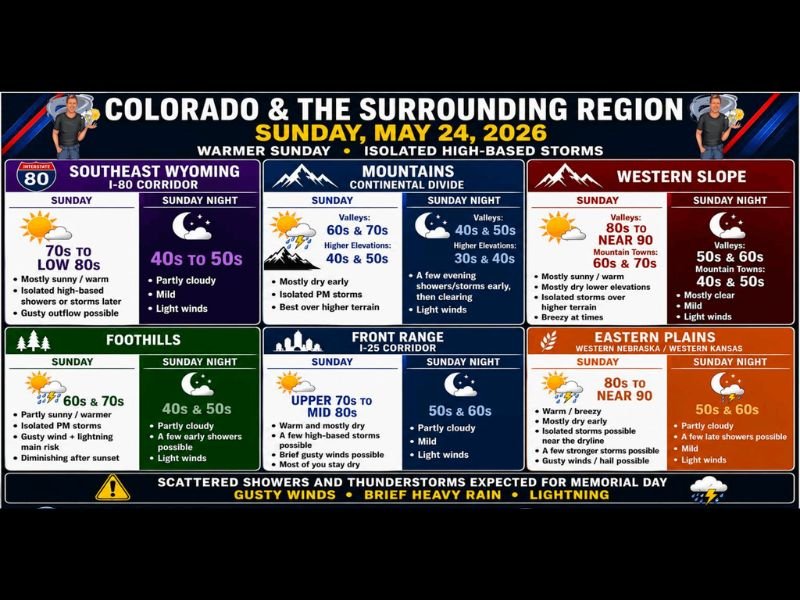
COLORADO AND SURROUNDING REGION — A warmer and mostly dry Sunday, May 24, 2026, is in store across Colorado and the surrounding region, but isolated high-based showers and thunderstorms will develop over the higher terrain and may spill onto the Front Range, I-25 corridor, and eastern plains through the afternoon. A dryline setting up across eastern Colorado into western Kansas and Nebraska could spark a couple of strong storms along that boundary, while Memorial Day Monday brings scattered hit or miss showers and thunderstorms with gusty winds, brief heavy rain, and lightning as the main concerns statewide.
Isolated High-Based Storms Most Common Over Higher Terrain With Spillover Onto Front Range
Sunday’s storm activity will be most common over the Colorado mountains and higher terrain, with isolated PM storms developing in a high-based environment through the afternoon hours. Mountain valley highs will reach the 60s and 70s while higher elevations stay in the 40s and 50s, with a few evening showers and storms early before light winds and clearing conditions arrive overnight.
The foothills will see partly sunny and warmer conditions with isolated afternoon storms, gusty winds, and lightning as the main risks before activity diminishes after sunset. Highs in the foothills will reach the 60s and 70s with overnight lows dropping to the 40s and 50s.
Dryline Across Eastern Colorado Into Western Kansas Could Spark Strong Afternoon Storms
A dryline setting up across eastern Colorado and into western Kansas and Nebraska will be a focal point for storm development Sunday afternoon. A couple of those storms could reach strong intensity along the boundary where warm dry air to the west clashes with denser and more humid air pushing in from the east.
Eastern plains highs will surge to 80s to near 90 degrees with warm and breezy conditions through the morning before isolated to stronger storms become possible through the afternoon and evening. Gusty winds and hail are both possible with any stronger storm that develops along or near the dryline boundary through the day.
Front Range and I-25 Corridor Warm and Mostly Dry With a Few High-Based Storms Possible
The Front Range and I-25 corridor will be warm and mostly dry Sunday with highs reaching the upper 70s to mid 80s, making it one of the warmest days of the upcoming week. A few high-based storms are possible through the afternoon with brief gusty winds possible, though most of the day will stay dry for the majority of the corridor.
Southeast Wyoming along the I-80 corridor will reach the 70s to low 80s with isolated high-based showers or storms later in the day and gusty outflow possible. The Western Slope will be mostly sunny and warm with valley highs reaching the 80s to near 90 degrees and isolated storms over the higher terrain through the afternoon.
Memorial Day Brings Scattered Storms With Gusty Winds, Heavy Rain, and Lightning Statewide
Memorial Day Monday will likely be one of the warmest days of the week before a blocking pattern begins to settle into place, bringing a gradual cooling trend back toward the 70s for much of the following week. Scattered hit or miss showers and thunderstorms are expected statewide on Memorial Day with gusty winds, brief heavy rain, and lightning identified as the primary hazards.
A large ridge of high pressure building over the central and northern Plains will eventually extend into southern Canada, creating a pattern where daily scattered storm opportunities become a reliable and recurring fixture across Colorado through the coming week. Residents should expect an active and unsettled weather pattern to persist well into the week ahead. Stay with NapervilleLocal.com for the latest weather updates and local forecast coverage.

I’ve lived in Naperville long enough to see how quickly our community changes — from new developments downtown to sudden shifts in our Midwest weather. Reporting on Naperville news and daily forecasts gives me the chance to keep neighbors informed about what really matters. My goal is simple: deliver clear, timely updates so you always know what’s happening in our city and what to expect from the skies above.