
Scattered Showers and Hit or Miss Thunderstorms Developing Across North Carolina and Tennessee Including Asheville, Charlotte, and Raleigh Through This Afternoon and Evening
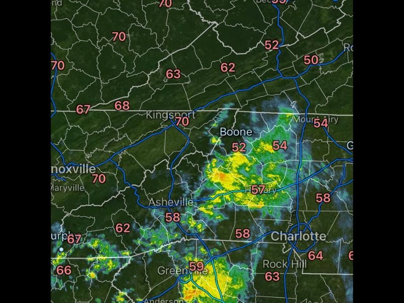
NORTH CAROLINA AND TENNESSEE — Scattered showers are active across the western portions of North Carolina and Tennessee this Saturday morning, mainly across the western zones, and will continue through early afternoon before hit or miss showers and thunderstorms develop more broadly across the state through the afternoon and evening hours. Radar at 9:25AM shows active green and yellow signatures concentrated across the Asheville, Boone, and western mountain corridor with temperatures ranging from the mid 50s to low 80s across the region.
Western Mountain Corridor Seeing the Most Active Morning Shower Coverage
The heaviest morning shower activity is concentrated across the western North Carolina mountains, with moderate radar returns visible near Asheville, Boone, and the Kingsport corridor on Saturday morning. Temperatures in the active zones range from 52 to 58 degrees across the higher terrain while Knoxville and Kingsport are sitting in the upper 60s to 70 degrees.
This western shower activity will persist through early afternoon before gradually shifting as afternoon heating begins to drive storm development more broadly across the state. Residents in the mountain communities should expect on and off shower activity through the midday hours.
Hit or Miss Showers and Thunderstorms to Spread Statewide This Afternoon and Evening
As morning showers continue across the west, scattered showers and thunderstorms will develop in a hit or miss fashion across the broader state through the afternoon and evening hours. The Greensboro, Raleigh, and Charlotte corridors will all be in play for afternoon storm development as daytime heating increases instability across the piedmont and eastern zones.
Temperatures across the central and eastern portions of the state range from the mid 60s through the upper 70s, with Fayetteville at 66, Wilmington at 77, and Bald Head Island reaching 81 degrees. These warmer temperatures combined with available moisture will support scattered afternoon and evening storm development across a wide area.
Statewide Weather Awareness Needed Through the Evening as Storm Chances Remain Hit or Miss
The hit or miss nature of today’s storm coverage means some communities will see significant activity while others stay completely dry through the afternoon and evening. Staying connected to local radar trends will be the best tool for residents trying to time outdoor activities around the scattered storm threat Saturday.
Anyone across North Carolina and the Tennessee border region with evening outdoor plans should have a weather contingency ready and monitor conditions as the afternoon progresses. The storm threat is not severe in nature but locally heavy rain and lightning are possible with any cells that develop through the evening hours. Stay with NapervilleLocal.com for the latest weather updates and local forecast coverage.

I’ve lived in Naperville long enough to see how quickly our community changes — from new developments downtown to sudden shifts in our Midwest weather. Reporting on Naperville news and daily forecasts gives me the chance to keep neighbors informed about what really matters. My goal is simple: deliver clear, timely updates so you always know what’s happening in our city and what to expect from the skies above.