
40mph Wind Gusts and Pea Size Hail Moving South Across North Texas Including Gainesville, Denton and DFW Sunday Morning With Storm Line Reaching Dallas by 12:16PM
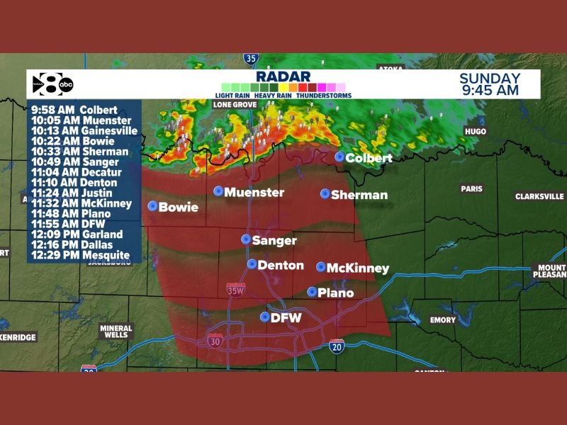
NORTH TEXAS — Showers and storms are moving south across the Red River into North Texas at 30 mph as of the 9:45 AM radar update on Sunday, May 10, 2026, capable of 40 mph wind gusts and isolated pea size hail. Nothing severe is expected with this first round of storm activity through the morning hours. A detailed arrival time breakdown shows the storm line reaching Gainesville at 10:13 AM, Denton at 11:10 AM, the DFW metroplex at 11:55 AM, Dallas at 12:16 PM, and Mesquite at 12:29 PM.
Storm Line Moving South at 30mph With 40mph Gusts and Pea Size Hail
Radar at 9:45 AM shows an active line of showers and thunderstorms pushing southward from Oklahoma across the Red River, with yellow, orange, and red returns indicating areas of heavy rain and embedded thunderstorm activity. The storm motion at 30 mph southward is bringing this line through the North Texas communities in a fairly rapid and organized fashion through the late morning hours.
Wind gusts up to 40 mph and isolated pea size hail are the primary hazards with this non-severe morning round of storms crossing the region.
Detailed Arrival Times From Colbert Through Dallas and Mesquite
The storm line arrival timeline begins with Colbert at 9:58 AM and Muenster at 10:05 AM, followed by Gainesville at 10:13 AM and Bowie at 10:22 AM. Sherman arrives at 10:33 AM with Sanger at 10:49 AM, Decatur at 11:04 AM, and Denton at 11:10 AM.
The DFW airport area sees the line at 11:55 AM, with Garland at 12:09 PM, Dallas at 12:16 PM, and Mesquite closing out the timeline at 12:29 PM as the storm line pushes through the full metroplex.
Main Severe System Still Expected to Develop After 3PM Across North Central Texas
While this morning round remains non-severe, the main and more dangerous severe weather system is still expected to take shape after 3 PM across North Central Texas. Residents across the DFW metroplex should remain weather aware through the afternoon and evening hours as the primary severe weather threat window runs through 10 PM Sunday.
Stay with NapervilleLocal.com for the latest weather updates and local forecast coverage.

I’ve lived in Naperville long enough to see how quickly our community changes — from new developments downtown to sudden shifts in our Midwest weather. Reporting on Naperville news and daily forecasts gives me the chance to keep neighbors informed about what really matters. My goal is simple: deliver clear, timely updates so you always know what’s happening in our city and what to expect from the skies above.