
Storms Dropping South From Oklahoma Into North Texas Including Gainesville, Denton and Fort Worth After 11AM Sunday With Main Severe System Building After 3PM Through 10PM
NORTH TEXAS — The first batch of storms from Oklahoma is dropping southward into North Texas after 11 AM on Sunday, May 10, 2026, with radar at 9:03 AM already showing intense red and orange cores moving through the Ardmore corridor toward Gainesville and Denton. These early storms are largely weakening and not expected to be severe between 11 AM and 2 PM. The main and more dangerous system then takes shape after 3 PM with storm risk continuing across North Central Texas through 10 PM.
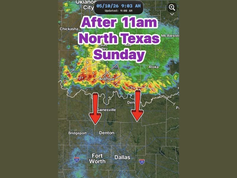
First Batch of Storms Arriving in North Texas After 11AM Mostly Weakening
Radar at 9:03 AM shows a line of intense storms moving southward from near Oklahoma City and Chickasha through Ardmore and tracking toward the Texas border near Gainesville and Denison. Red arrows confirm the southward storm motion pushing directly toward Denton, Fort Worth, and Dallas through the late morning hours.
Despite the impressive radar presentation, these storms are expected to weaken during the 11 AM to 2 PM window and are not anticipated to produce widespread severe weather as they cross into North Texas.
Main Severe System Takes Shape After 3PM With Risk Continuing Through 10PM
The more significant and organized severe weather threat begins after 3 PM as the main system takes shape across North Central Texas. This afternoon and evening round carries the higher severe weather potential compared to the weakening morning storms arriving from Oklahoma.
The storm risk window extends through 10 PM, giving residents across the DFW metroplex, Gainesville, Denton, and surrounding North Central Texas communities a prolonged afternoon and evening severe weather window to monitor closely.
Residents Should Monitor Closely as Stronger Storms Possible After 3PM Today
With the main event arriving after 3 PM, North Texas residents should use the late morning and early afternoon hours to prepare and ensure weather alerts are active on all devices. The gap between the weakening morning storms and the more organized afternoon system provides a critical preparation window before the primary severe weather risk develops across the region.
Stay with NapervilleLocal.com for the latest weather updates and local forecast coverage.

I’ve lived in Naperville long enough to see how quickly our community changes — from new developments downtown to sudden shifts in our Midwest weather. Reporting on Naperville news and daily forecasts gives me the chance to keep neighbors informed about what really matters. My goal is simple: deliver clear, timely updates so you always know what’s happening in our city and what to expect from the skies above.