
Georgia Faces Warm, Muggy Friday as Scattered Thunderstorms Target Atlanta, Gainesville, Dalton and Athens With Heavy Rain Risk
ATLANTA, GEORGIA — Warm and muggy conditions are expected to settle across north and central Georgia on Friday, bringing scattered afternoon thunderstorms that could affect cities including Dalton, Calhoun, Gainesville, Atlanta, and Athens. Forecasters say the combination of rising temperatures and increasing humidity will help spark storms shortly after lunchtime and continue into the evening hours.
Temperatures across the region are forecast to climb into the upper 70s and low to mid-80s by the afternoon, creating the kind of warm and unstable atmosphere that often fuels springtime thunderstorm development.
Warm, Humid Air Creating Storm-Friendly Conditions
Friday’s weather pattern will feel more like early summer across much of Georgia. High temperatures are expected to range between 79°F and 84°F, while dew points rising into the 60s will create noticeably muggy conditions.
This moisture in the atmosphere plays a key role in thunderstorm formation. As daytime heating builds through the late morning and early afternoon, instability in the air will increase, making it easier for thunderstorms to form across parts of north Georgia.
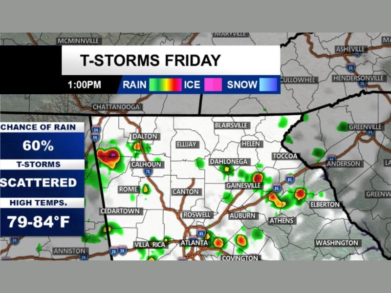
Meteorologists estimate about a 60% chance of rain during the day, indicating scattered storms could appear in multiple locations rather than forming one continuous storm system.
Storms Expected to Begin Early Afternoon
Forecast models show thunderstorms beginning to develop around 1:00 PM, with the first activity likely appearing across areas near Dalton, Calhoun, and Rome before gradually spreading toward Gainesville and the greater Atlanta area.
As the afternoon progresses, storms may expand along major travel corridors such as Interstate 75 and Interstate 85, bringing bursts of rain and lightning to metro areas and surrounding communities.
By mid to late afternoon, additional storms may develop across northeast Georgia, potentially affecting cities such as Gainesville, Auburn, Athens, and Covington.
Heavy Rain, Lightning and Gusty Winds Possible
While not every storm will become severe, some stronger cells could produce heavy rainfall, frequent lightning, and gusty winds. These storms may bring short-lived downpours capable of reducing visibility for drivers and briefly flooding low-lying roadways.
Lightning could also create hazards for outdoor activities, especially during the peak storm hours of the afternoon.
Because the storms are expected to remain scattered, rainfall totals may vary widely. Some neighborhoods could see intense rain for a short time, while others nearby may only experience passing showers.
Evening Storms Could Continue Before Gradual Clearing
Thunderstorm activity may continue into the early evening hours as the humid air mass remains in place across the region. Areas east of Atlanta, including Athens and surrounding communities, could still experience lingering storms before conditions gradually calm later at night.
Residents across north and central Georgia are encouraged to monitor weather updates and remain aware of rapidly changing conditions Friday afternoon and evening as scattered thunderstorms move through the region.

I’ve lived in Naperville long enough to see how quickly our community changes — from new developments downtown to sudden shifts in our Midwest weather. Reporting on Naperville news and daily forecasts gives me the chance to keep neighbors informed about what really matters. My goal is simple: deliver clear, timely updates so you always know what’s happening in our city and what to expect from the skies above.