
Illinois, Missouri, Iowa Brace for Significant Severe Weather Tuesday as Strong Tornadoes, Large Hail, and Damaging Winds Threaten Mid-Mississippi Valley
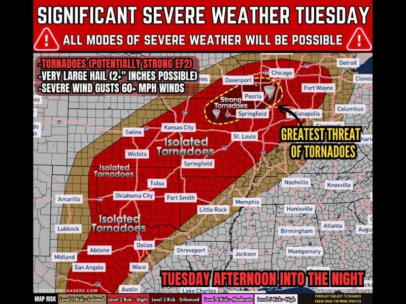
ILLINOIS — A significant severe weather outbreak could unfold Tuesday afternoon and evening across parts of the Mid-Mississippi Valley, with meteorologists warning that Missouri, Illinois, and far southeast Iowa may face the greatest threat for strong tornadoes, very large hail, and damaging wind gusts.
The developing system is expected to trigger scattered to widespread thunderstorms beginning Tuesday afternoon before intensifying into the evening hours. The most dangerous storms could form near a warm front and triple-point setup across Missouri and Illinois, where atmospheric conditions appear favorable for severe storm development.
Strong Tornadoes Possible Across Missouri, Illinois, and Southeast Iowa
Forecasters say all modes of severe weather will be possible, including tornadoes that could become strong in some locations. The corridor of greatest concern currently stretches from eastern Kansas and Missouri into Illinois and far southeast Iowa, where storm environments may support rotating supercells capable of producing tornadoes.
Cities within or near this corridor include Kansas City, Springfield (Missouri), St. Louis, Peoria, Springfield (Illinois), and Davenport, where storms may intensify during the late afternoon and evening hours. If discrete storms develop ahead of the main storm clusters, the tornado risk could increase significantly in localized areas.
Very Large Hail and 60+ MPH Winds Also Major Concerns
In addition to tornadoes, meteorologists warn that storms could produce large to very large hail, particularly with any isolated supercells that develop early in the event.
Hailstones larger than two inches in diameter are possible in the strongest storms, capable of damaging vehicles, roofs, and crops.
As storms organize later in the evening, the threat may shift toward damaging straight-line winds exceeding 60 mph, especially if thunderstorms merge into lines or clusters moving northeast across the region. Communities across Missouri, Illinois, and southeast Iowa could see rapidly changing conditions as these storms evolve.
Storm Development Expected Tuesday Afternoon and Evening
Storm activity is expected to begin developing during the Tuesday afternoon hours, primarily within the warm sector of the developing storm system.
As the evening progresses, storms may increase in coverage and organization along several weather boundaries, including a dryline, warm front, and eventual cold front that will help trigger thunderstorm development.
Meteorologists note that two areas of low pressure are expected to form — one near the Texas–Oklahoma Panhandle region and another near northwest Missouri extending toward Iowa. This setup will help draw warm, moisture-rich air northward while strong wind shear develops overhead, creating an environment supportive of severe thunderstorms.
Large Region at Risk Across the Southern Plains and Mid-Mississippi Valley
The severe weather threat Tuesday could extend across a large portion of the central United States.
Areas expected to see potential impacts include:
- Texas
- Oklahoma
- Eastern Kansas
- Missouri
- Illinois
- Iowa
- Other parts of the Mid-Mississippi Valley
While not every community will see severe weather, scattered storms across this region could quickly become intense, particularly where the most favorable atmospheric conditions align.
Forecast Still Evolving as Meteorologists Monitor Storm Setup
Forecasters emphasize that some uncertainty remains regarding how storms will initiate and organize, which could influence where the most intense storms ultimately develop.
However, strong wind shear, increasing instability, and abundant Gulf moisture indicate that scattered to widespread severe thunderstorms remain a strong possibility Tuesday afternoon into Tuesday night across Missouri, Illinois, and nearby states.
Residents across the Mid-Mississippi Valley are encouraged to monitor weather updates closely as the forecast continues to evolve and the potential severe weather event approaches.

I’ve lived in Naperville long enough to see how quickly our community changes — from new developments downtown to sudden shifts in our Midwest weather. Reporting on Naperville news and daily forecasts gives me the chance to keep neighbors informed about what really matters. My goal is simple: deliver clear, timely updates so you always know what’s happening in our city and what to expect from the skies above.