
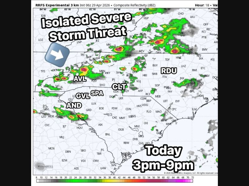
Isolated Strong to Severe Storms With Tornado Threat East of I-77 Possible Across North Carolina Including Charlotte, Raleigh, and Asheville Between 3 PM and 9 PM Today
NORTH CAROLINA — The environment is becoming favorable for storms to redevelop across North Carolina this Wednesday afternoon, with a few capable of turning strong to severe between 3 PM and 9 PM today, April 29, 2026. Most areas will stay dry through the afternoon, but where storms do develop they could pack a significant punch across communities including Asheville, Greenville, Spartanburg, Charlotte, and the Raleigh-Durham corridor. A tornado threat that is not zero exists east of Interstate 77 in North Carolina, where just enough wind energy is present in the atmosphere to support rotation with the strongest storms.
Environment Becoming Favorable for Storm Redevelopment This Afternoon Across the Region
The RRFS experimental model valid for this afternoon shows scattered storm development firing across a broad area from the western Carolinas eastward through Charlotte and into the Raleigh-Durham corridor between 3 PM and 9 PM. The atmosphere has recovered enough after this morning’s activity to support isolated strong to severe storm development during the peak afternoon and early evening heating hours.
Radar simulation shows the most concentrated storm activity developing across the Upstate South Carolina and western North Carolina corridor near Asheville, Greenville, and Spartanburg before additional cells push eastward toward Charlotte and the Piedmont through the evening. The isolated nature of today’s threat means storm coverage will be limited but individual cell intensity could be significant.
Tornado Threat Not Zero East of I-77 With Enough Wind Energy in the Atmosphere
Forecasters note that the tornado threat with today’s storms is not zero, particularly east of Interstate 77 in North Carolina where wind shear values are sufficient to support rotation with stronger storm cells. This corridor east of I-77 encompasses a large and densely populated area including Charlotte, the Research Triangle, and communities stretching toward the coast.
While the tornado risk is not the primary concern today and remains conditional, any storm producing a brief tornado in a populated area can cause significant damage. Residents east of I-77 across North Carolina should keep weather alerts active through 9 PM and be prepared to act quickly if a warning is issued for their location.
Most Areas Stay Dry But Storms That Form Could Pack a Significant Punch
The isolated character of today’s severe weather setup means the vast majority of communities across the Carolinas will experience little to no storm activity through the afternoon and evening. However, the storms that do develop will have access to enough atmospheric instability and wind energy to produce damaging winds, hail, and potentially a brief tornado in localized areas.
Anyone with outdoor evening plans across western North Carolina, the Charlotte metro, or the Raleigh-Durham area should monitor conditions closely between 3 PM and 9 PM today. Having a weather alert active on a mobile device is the most reliable way to receive timely warning information if a storm approaches. Stay with NapervilleLocal.com for the latest weather updates and local forecast coverage.

I’ve lived in Naperville long enough to see how quickly our community changes — from new developments downtown to sudden shifts in our Midwest weather. Reporting on Naperville news and daily forecasts gives me the chance to keep neighbors informed about what really matters. My goal is simple: deliver clear, timely updates so you always know what’s happening in our city and what to expect from the skies above.