
Damaging Wind Gusts and Spin-Up Tornado Possible Across South Mississippi Including Hattiesburg, Laurel, and Gulfport This Evening Between 6 PM and Midnight
SOUTH MISSISSIPPI — A complex of storms is expected to develop to the north and west this afternoon and push toward South Mississippi through the evening hours of Wednesday, April 29, 2026. If the storm complex holds together on its track southward, isolated damaging wind gusts and a quick spin-up tornado cannot be ruled out across communities including Hattiesburg, Laurel, Quitman, Wiggins, Lucedale, and the Gulfport corridor.
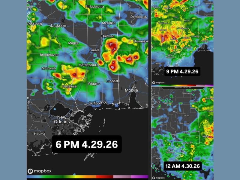
HRRR model imagery shows the storm complex arriving across the region around 6 PM and continuing to push through into the 9 PM and midnight timeframe before gradually exiting the area.
Storm Complex Expected to Arrive Across South Mississippi Around 6 PM This Evening
HRRR model simulations valid for 6 PM on April 29 show a complex of storms pushing into the South Mississippi region from the north and west, with the heaviest storm cores focused across the Hattiesburg, Laurel, and Quitman corridor during the early evening hours. The storm complex will need to maintain its organization as it tracks southward through the afternoon for the most significant severe weather potential to be realized this evening.
The movement of this complex from the north and west is a key factor in determining how impactful tonight’s storms become across South Mississippi. Communities along the storm’s projected path should begin monitoring conditions closely as the afternoon progresses and the complex approaches.
Isolated Damaging Wind Gusts and Spin-Up Tornado Cannot Be Ruled Out
Should the storm complex hold together through its southward track, isolated damaging wind gusts are the primary hazard for South Mississippi this evening. Linear storm complexes of this type are capable of producing widespread wind damage along their leading edge, with gusts capable of downing trees, snapping power lines, and causing structural damage across communities in the direct path.
A quick spin-up tornado also cannot be ruled out with this type of storm complex, particularly where storm-scale rotation develops along the leading edge or within embedded cells. Spin-up tornadoes associated with storm complexes can develop rapidly and with limited warning time, making it critical to have weather alerts active through the entire evening window.
Storm Activity Continues Through 9 PM Before Gradually Clearing Around Midnight
Model imagery shows storm activity persisting across South Mississippi through the 9 PM timeframe, with the complex gradually shifting toward the Gulf Coast and Mobile area through the late evening hours. The midnight simulation shows a weakening trend as the complex pushes toward the coast and begins to lose organization over the cooler Gulf waters.
Residents across Hattiesburg, Laurel, Wiggins, Lucedale, McComb, Bogalusa, and the Gulfport and Mobile corridors should keep weather alerts active through midnight tonight. The storm complex could still produce impactful conditions even during its weakening phase as it exits the region. Stay with NapervilleLocal.com for the latest weather updates and local forecast coverage.

I’ve lived in Naperville long enough to see how quickly our community changes — from new developments downtown to sudden shifts in our Midwest weather. Reporting on Naperville news and daily forecasts gives me the chance to keep neighbors informed about what really matters. My goal is simple: deliver clear, timely updates so you always know what’s happening in our city and what to expect from the skies above.