
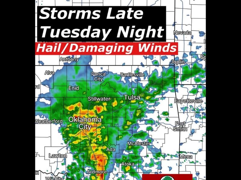
Oklahoma Storm Alert: Late-Night Thunderstorms Could Bring Large Hail and Damaging Winds From Oklahoma City Toward Tulsa Overnight
OKLAHOMA — Storm chances are expected to increase across Oklahoma late Tuesday night as a developing storm system approaches from the west, potentially bringing large hail and damaging wind gusts to parts of the state overnight.
Forecast discussions indicate that thunderstorms are likely to begin forming across western Oklahoma Tuesday evening, before gradually moving eastward across the state during the nighttime hours. While the strongest severe weather may remain west of Tulsa, storms are expected to maintain their strength as they travel east across central and eastern Oklahoma through the overnight period.
Storms Expected to Develop in Western Oklahoma
Meteorologists say the first storms should begin forming across western Oklahoma during the evening hours Tuesday as the approaching system provides the energy needed for thunderstorm development.
Cities near the early storm zone could include areas around Weatherford, Enid, and parts of western Oklahoma, where initial storm clusters may begin organizing. As the evening progresses, these storms are forecast to move east toward larger population centers across central Oklahoma.
Oklahoma City Area Could See Storm Clusters
Forecast models suggest storm clusters could develop and strengthen near Oklahoma City and surrounding communities, where radar projections show bands of thunderstorms expanding through the region.
These storms could produce bursts of heavy rain along with large hail and strong wind gusts, particularly if clusters become more organized as they move across the state. Hail and wind appear to be the primary hazards associated with this system.
Storms Move Toward Eastern Oklahoma Overnight
As the storm system continues eastward overnight, storms may reach communities across eastern Oklahoma late Tuesday night or early Wednesday morning. Cities including Tulsa, Bartlesville, McAlester, and areas closer to the Arkansas border could see thunderstorms arriving later in the night.
While the highest severe weather risk currently appears to stay west of Tulsa, storms could still produce gusty winds and pockets of hail as they move across the region.
Timing and Strength Still Being Monitored
Forecasters say the exact timing and intensity of the storms could change as new weather data becomes available.
Key points residents should know include:
- Thunderstorms likely developing in western Oklahoma Tuesday evening
- Storms expected to move east across the state overnight
- Large hail and damaging wind gusts possible in stronger storms
- Storms could reach eastern Oklahoma late Tuesday night or early Wednesday
Meteorologists say they will continue monitoring new forecast data over the next 24 hours to better determine how strong the storms may become. Residents across Oklahoma are encouraged to stay alert to updated forecasts and weather alerts Tuesday evening as the approaching storm system moves into the region.

I’ve lived in Naperville long enough to see how quickly our community changes — from new developments downtown to sudden shifts in our Midwest weather. Reporting on Naperville news and daily forecasts gives me the chance to keep neighbors informed about what really matters. My goal is simple: deliver clear, timely updates so you always know what’s happening in our city and what to expect from the skies above.