
Florida Cold Snap Ahead: Tallahassee Wind Chills Near 35° While Orlando, Tampa and Jacksonville Turn Much Cooler by March 16
FLORIDA — After a stretch of unusually warm weather, forecast models are now hinting at a surprising cold comeback across Florida next week, with wind chills potentially dropping into the 30s across parts of North Florida by Tuesday morning, March 16.
Early projections from the European weather model suggest a sharp temperature change that could feel dramatically different compared with the recent heatwave conditions across the state. If the forecast trend holds, several Florida cities could wake up to wind chills that feel more like late winter than mid-March.
North Florida Could See the Coldest Conditions
The coldest wind chills are expected across North Florida, where brisk winds combined with cooler temperatures may push apparent temperatures into the mid-30s.
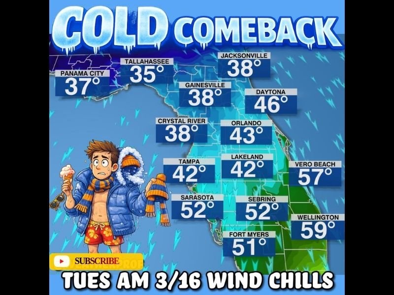
Forecast wind chill estimates currently include:
- Tallahassee: around 35°
- Panama City: near 37°
- Jacksonville: around 38°
- Gainesville: near 38°
While these temperatures may not be unusual for winter, they could feel especially cold after the recent period of warmth across the region.
Central Florida Also Turns Much Cooler
Central Florida is also expected to feel the impact of the incoming cold air mass, although conditions there will remain slightly milder.
Forecast wind chills include:
- Orlando: about 43°
- Lakeland: around 42°
- Crystal River: near 38°
- Tampa: roughly 42°
Even though these numbers remain above freezing, they would represent a noticeable drop from the warmer weather many residents have experienced recently.
South Florida Remains the Mildest
Farther south, the cold air will weaken somewhat before reaching the southern peninsula. Still, many locations could see a cooler morning than usual for mid-March.
Projected wind chills include:
- Vero Beach: around 57°
- Wellington: near 59°
- Sebring: about 52°
- Sarasota: around 52°
- Fort Myers: near 51°
These values suggest South Florida will remain relatively mild compared with the northern half of the state.
A Sharp Contrast After Recent Warmth
Meteorologists say the biggest story may be the contrast between recent heat and the incoming cooler air. The sudden change could make temperatures feel significantly colder than they actually are, particularly during the early morning hours when winds are strongest.
Forecast models continue to evolve, and the exact strength of the cold air mass may change over the coming days. However, current guidance suggests Florida residents could experience a brief reminder of winter before spring conditions return.
For now, forecasters say it’s worth keeping an eye on updates as the forecast develops, especially for North Florida where the coldest wind chills appear most likely early Tuesday morning.

I’ve lived in Naperville long enough to see how quickly our community changes — from new developments downtown to sudden shifts in our Midwest weather. Reporting on Naperville news and daily forecasts gives me the chance to keep neighbors informed about what really matters. My goal is simple: deliver clear, timely updates so you always know what’s happening in our city and what to expect from the skies above.