
Fast-Moving Storm Line Sweeps Across Tennessee and North Carolina Bringing Heavy Rain, Temperature Crash, and Possible Damaging Winds
ASHEVILLE, NORTH CAROLINA — A line of showers and thunderstorms was pushing east across the southern Appalachian region early this morning, bringing heavy rain and gusty winds from eastern Tennessee into western and central North Carolina as temperatures begin to plunge behind the front.
Meteorologists tracking the system around 7:33 a.m. reported that the storm line would continue progressing east through the morning and afternoon, producing scattered downpours and occasional thunderstorms along its path.
While widespread severe weather is not expected, forecasters say an isolated severe storm with damaging winds cannot be ruled out as the line moves across the region.
Storm Line Moving From Tennessee Into Western North Carolina
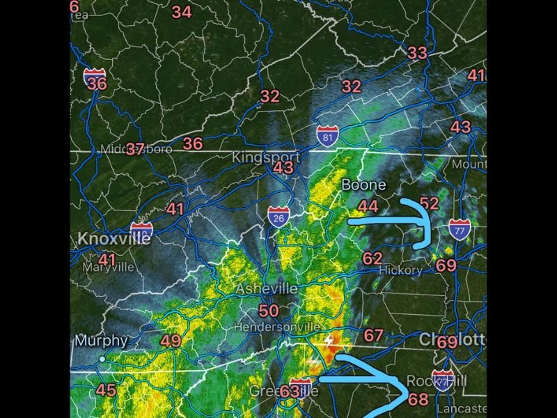
Radar imagery shows a band of rain and thunderstorms extending from eastern Tennessee near Knoxville into western North Carolina around Asheville and Boone.
Communities including Murphy, Asheville, Hendersonville, and Boone were experiencing periods of moderate to heavy rain as the system advanced eastward. Some embedded thunderstorms within the line were producing lightning and locally heavier rainfall as they pushed toward the North Carolina foothills and Piedmont region.
Temperatures Crash Behind the Passing Front
One of the biggest impacts from the storm line will be a sharp drop in temperatures once the front moves through. Temperatures ahead of the storms across parts of the region were sitting in the 60s and even upper 60s, including readings near 67 to 69 degrees around Charlotte and Rock Hill.
However, behind the storm line temperatures had already dropped dramatically into the 40s and even low 30s across parts of Tennessee and southwestern Virginia.
Cities such as Kingsport and surrounding areas were reporting temperatures in the low 40s, while locations farther north were seeing readings near the low 30s. As the line continues moving east through the afternoon, temperatures are expected to fall quickly across much of western and central North Carolina.
Heaviest Rain Bands Passing Through Asheville and Greenville Areas
The most concentrated rainfall early this morning was occurring across western North Carolina, particularly near Asheville and surrounding mountain communities.
Additional thunderstorms were also developing farther south near Greenville, South Carolina, where temperatures remained warmer ahead of the front. These areas could see brief bursts of heavier rain and gusty winds as the storms pass through.
Isolated Damaging Wind Gusts Still Possible
Although the primary impact from this system will be rain and falling temperatures, forecasters caution that a few storms embedded in the line could briefly produce damaging wind gusts.
These isolated stronger cells may develop as the storms track east toward Hickory, Charlotte, and surrounding communities later today.
Once the front clears the region later this afternoon, conditions are expected to turn cooler with breezy winds continuing behind the departing storm system.

I’ve lived in Naperville long enough to see how quickly our community changes — from new developments downtown to sudden shifts in our Midwest weather. Reporting on Naperville news and daily forecasts gives me the chance to keep neighbors informed about what really matters. My goal is simple: deliver clear, timely updates so you always know what’s happening in our city and what to expect from the skies above.