
Michigan Upper Peninsula Blizzard Threat: Marquette, Houghton and Keweenaw Peninsula Could See Up to 4 Feet of Snow by Tuesday
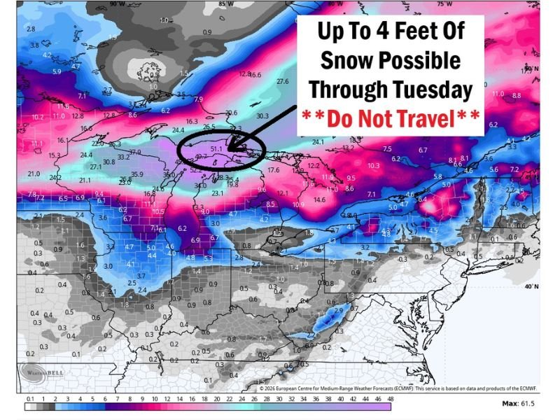
UPPER PENINSULA, MICHIGAN — A potentially historic winter storm is expected to strike Michigan’s Upper Peninsula beginning Sunday and continuing through early next week, with forecasters warning that snowfall totals could reach or even exceed four feet in some areas.
Meteorologists say the storm will arrive in multiple phases, starting with an initial snow event that could bring around six inches before a powerful blizzard develops late Sunday with intense winds and heavy snowfall continuing into Monday.
Early Snowfall Begins Before Major Blizzard Arrives
The first round of the storm is already producing accumulating snow across northern Michigan. A Winter Storm Warning has been issued as the initial system moves through, with roughly six inches of snow possible during the first phase of the event.
While this first round may resemble a typical winter storm for the region, forecasters say conditions are expected to deteriorate rapidly as the more powerful system arrives Sunday. Meteorologists warn that the incoming storm will be far more intense than a standard Michigan snowstorm.
Blizzard Conditions Possible Sunday into Monday
Beginning Sunday, a strong blizzard could develop across the Upper Peninsula as heavy snowfall combines with powerful winds. Forecast models indicate wind gusts near 60 mph, which could create dangerous whiteout conditions and blowing snow across large portions of the region.
These conditions may significantly reduce visibility and make travel extremely hazardous across highways and rural roads throughout the Upper Peninsula. Communities across the Keweenaw Peninsula and northern parts of the region may be among the hardest hit as the storm intensifies.
Snow Totals Could Reach 2 to 3 Feet by Monday
Meteorologists say snowfall could rapidly accumulate as the blizzard intensifies. Forecast projections indicate two to three feet of additional snow could fall by Monday, on top of the initial snowfall that begins earlier in the weekend.
The heavy snowfall combined with strong winds may create deep snowdrifts, making travel extremely difficult or even impossible in some areas. Officials warn that road conditions could deteriorate quickly as the storm develops.
Lake-Effect Snow May Extend the Storm into Tuesday
Even after the main blizzard weakens, the weather pattern may continue producing significant snowfall across the Upper Peninsula. Cold air moving across Lake Superior could trigger several additional inches of lake-effect snow on Tuesday, extending the duration of the storm.
Because of this prolonged snowfall, total accumulations across parts of northern Michigan could approach or exceed four feet of snow by the time the event ends.
Travel Conditions Could Become Extremely Dangerous
Meteorologists are urging travelers to reconsider plans to visit northern Michigan during the storm period. With blizzard conditions possible, road travel could become extremely difficult across portions of the Upper Peninsula through early next week. In some areas, deep snow and drifting could limit vehicle travel, with snowmobiles potentially becoming one of the only ways to move around in remote northern communities.
Forecasters continue to monitor the developing storm closely as it approaches Michigan, warning that this could become one of the most significant snowfall events of the season across the Upper Peninsula.

I’ve lived in Naperville long enough to see how quickly our community changes — from new developments downtown to sudden shifts in our Midwest weather. Reporting on Naperville news and daily forecasts gives me the chance to keep neighbors informed about what really matters. My goal is simple: deliver clear, timely updates so you always know what’s happening in our city and what to expect from the skies above.