
TORCON 4 Issued Major Severe Storm Outbreak Risk From Indiana to Louisiana With 70 MPH Winds and Possible Tornadoes From Sunday to Monday
INDIANAPOLIS, INDIANA — A widespread severe weather threat is expected to develop across a large portion of the central and eastern United States as meteorologists warn of back-to-back storm threats Sunday and Monday, including the risk of tornadoes and damaging winds exceeding 70 miles per hour.
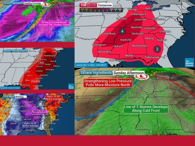
Forecasters have issued a TORCON 4 alert, signaling an elevated tornado risk across a broad region stretching from Indiana southward through Kentucky, Tennessee, Alabama, Mississippi and Louisiana. The storm threat is expected to expand eastward toward the Mid-Atlantic by Monday. The developing system is being driven by a strengthening low-pressure center moving through the Great Lakes while a powerful cold front pushes across the Midwest and South.
Tornado Threat Expands From Indiana Through the Deep South
Weather experts say the setup could support tornado development across a wide swath of the central United States.
Areas including Indianapolis and Louisville could see severe thunderstorms as the system develops, while cities farther south such as Nashville, Huntsville, Montgomery, Jackson and New Orleans may also face storm threats as the cold front sweeps through.
Tornadoes embedded within a fast-moving line of storms are possible, particularly as the atmosphere becomes increasingly unstable ahead of the advancing cold front. Meteorologists warn that even storms without tornadoes could still produce dangerous conditions.
Damaging Winds Could Exceed 70 Miles Per Hour
In addition to tornado potential, forecasters say straight-line winds may exceed 70 mph in some of the strongest storms.
Such powerful winds can cause:
- Widespread power outages
- Downed trees and power lines
- Damage to homes and buildings
- Hazardous driving conditions
A long line of thunderstorms is expected to develop along the advancing cold front, moving quickly across the region from west to east.
Storm Threat Continues Into the Mid Atlantic Monday
The severe weather threat will not end Sunday night. Forecasters say storms will likely continue into Monday, expanding eastward from the Southeast toward the Mid-Atlantic region.
Cities including Charlotte, Columbia, Savannah and Jacksonville may experience strong storms as the system moves east. By Monday afternoon and evening, the strongest storms could push into areas including Washington, D.C., Norfolk and other Mid-Atlantic communities, where severe thunderstorms remain possible.
Major Temperature Drop Expected Behind the Storms
Behind the powerful cold front, a dramatic temperature shift is expected across much of the country. Meteorologists say temperatures could fall as much as 30 degrees below average Monday in some regions after unusually warm conditions earlier in the week. This sudden shift could bring cooler air across large portions of the central United States as the storm system moves eastward.
Weather experts emphasize that conditions may change rapidly as the system develops, and residents across the affected states should closely monitor forecasts and weather alerts. Stay with NapervilleLocal.com for continued coverage of this developing severe weather outbreak and updates on major storm systems impacting communities across the United States.

I’ve lived in Naperville long enough to see how quickly our community changes — from new developments downtown to sudden shifts in our Midwest weather. Reporting on Naperville news and daily forecasts gives me the chance to keep neighbors informed about what really matters. My goal is simple: deliver clear, timely updates so you always know what’s happening in our city and what to expect from the skies above.