
Ohio Overnight Storm Line Near Cincinnati and Dayton Triggers Severe Thunderstorm Watch and Wind Advisory Through Early Morning
CINCINNATI, OHIO — A line of overnight thunderstorms moved across southwest Ohio early Monday morning, prompting a Severe Thunderstorm Watch and a Wind Advisory as meteorologists monitored storms stretching from Cincinnati toward Dayton and nearby communities.
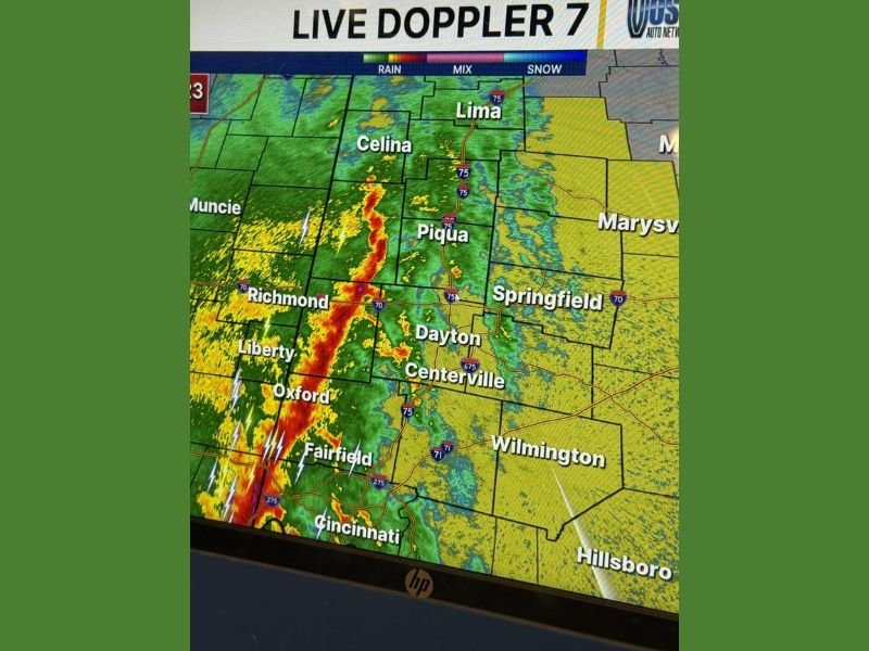
Weather radar showed a narrow but intense band of storms pushing northeast across the region, with the strongest activity located west of Cincinnati, Fairfield, and Oxford, gradually advancing toward Dayton, Centerville, and Piqua.
Officials noted that although storms have triggered a few warnings near the state line, conditions so far have remained below severe thresholds, with winds staying under the levels typically required for severe thunderstorm classification.
Severe Thunderstorm Watch Continues Until Early Morning
Meteorologists confirmed that a Severe Thunderstorm Watch remains in effect until 4:00 AM, covering communities across southwest Ohio as the storm system moves through the region. The watch was issued due to the potential for storms to intensify and produce damaging winds or isolated severe weather conditions overnight.
Cities included within the monitoring area include:
- Cincinnati
- Fairfield
- Oxford
- Dayton
- Centerville
- Piqua
- Celina
- Lima
Radar imagery showed the strongest storm band tracking from Cincinnati north toward Dayton, following a corridor roughly aligned with Interstate 75.
Wind Advisory Remains in Effect
Alongside the thunderstorm watch, a Wind Advisory remains active until 8:00 AM across counties in the region. Wind advisories are typically issued when sustained winds or gusts may create travel hazards or cause minor damage.
Although the storms have produced lightning and moderate rainfall, meteorologists say wind speeds have so far stayed below severe limits. However, strong gusts remain possible as the storm line continues to move northeast.
Storm Line Moving Through Key Ohio Communities
Radar images from the Live Doppler 7 system showed the storm band extending from areas near Cincinnati through Oxford and Fairfield, with storms gradually pushing toward Dayton and Centerville.
Additional rain bands were visible north of Dayton toward Piqua, Celina, and Lima, although these appeared weaker compared to the intense storm cells farther south. Lightning activity was concentrated within the main line of storms approaching the Cincinnati metro area earlier in the morning.
Conditions Being Closely Monitored
Meteorologists tracking the system say the storms are largely behaving as expected, with limited severe activity so far. Two warnings were issued earlier near the state line, but officials emphasized that the storms have not yet produced widespread severe weather impacts. Forecasters say the situation could still change as the storm line continues moving northeast.
Storm Risk Expected to Decrease After Sunrise
Weather experts believe the severe threat will gradually decrease as the storm line moves farther northeast and weakens later in the morning. However, scattered rain and gusty winds could still affect communities across the region through early morning hours.
Residents across Cincinnati, Dayton, and surrounding Ohio communities are encouraged to remain weather aware until the storms fully clear the area. Meteorologists will continue monitoring radar for any signs of strengthening storms that could trigger additional warnings. This article follows the newsroom formatting standards used for NapervilleLocal.com weather reporting .

I’ve lived in Naperville long enough to see how quickly our community changes — from new developments downtown to sudden shifts in our Midwest weather. Reporting on Naperville news and daily forecasts gives me the chance to keep neighbors informed about what really matters. My goal is simple: deliver clear, timely updates so you always know what’s happening in our city and what to expect from the skies above.