
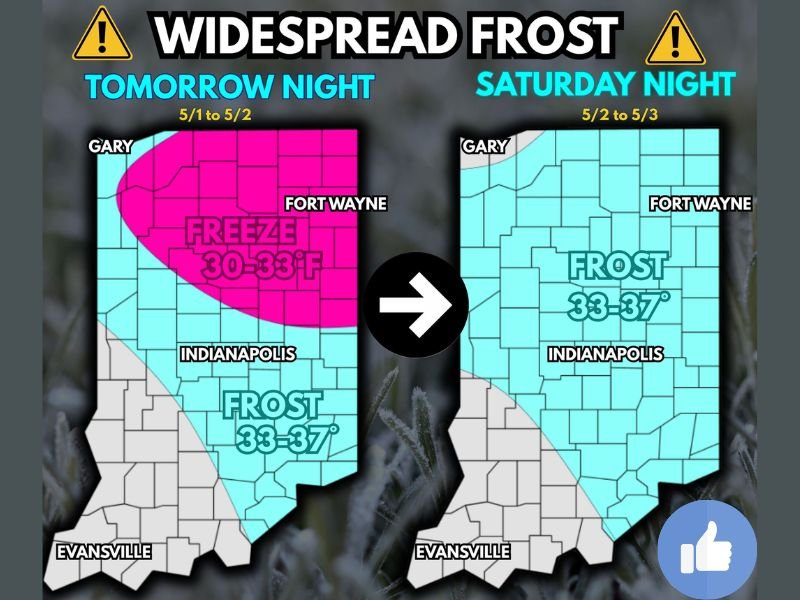
Widespread Frost and Hard Freeze Down to 30 Degrees Threatening Indiana Including Indianapolis, Gary, and Fort Wayne Friday Night Into Saturday With Agricultural Impacts Expected
INDIANA — A widespread frost and freeze event is expected across much of Indiana over the next two nights, with Friday night into Saturday morning bringing the most dangerous conditions of the two-night stretch. Temperatures are forecast to drop to 30 to 33 degrees across a large freeze zone covering northern and central Indiana including Gary, Fort Wayne, and Indianapolis Friday night May 1 into May 2, while the rest of the state sees frost conditions with lows of 33 to 37 degrees. Saturday night May 2 into May 3 then brings widespread frost conditions of 33 to 37 degrees expanding across nearly the entire state.
Hard Freeze of 30 to 33 Degrees Expected Across Northern and Central Indiana Friday Night
The most severe conditions arrive Friday night, when temperatures are forecast to plunge to 30 to 33 degrees across a broad freeze zone covering much of northern and central Indiana. Temperatures at this level constitute a hard freeze capable of killing or severely injuring a wide range of sensitive vegetation, garden plants, and newly emerged crops that have not hardened off to freezing conditions.
Residents across the freeze zone including communities near Gary, Fort Wayne, and Indianapolis should bring all sensitive potted plants indoors and cover any in-ground vegetation that cannot be moved before Friday night temperatures begin falling after midnight. The freeze zone on Friday night represents the most dangerous conditions for outdoor plants of the entire two-night event.
Agricultural Impacts Possible for Soybeans and Flowering Wheat Fields Statewide
The agricultural implications of this frost and freeze event are significant, with soybeans that have already emerged above ground facing potential injury or loss across the affected areas. Of particular concern are wheat fields that have reached the Feeks 10.5.1 flowering stage, as freezing temperatures during the flowering stage can cause substantial and irreversible damage to yield potential for those fields.
Farmers across Indiana with emerged soybeans or heading and flowering wheat should assess their fields and monitor overnight low temperatures closely through the weekend. Substantial impacts to flowering wheat fields are considered possible given the forecast temperature range during both Friday and Saturday nights.
Widespread Frost Returns Saturday Night Expanding Across Nearly the Entire State
Saturday night brings a second round of frost conditions, with temperatures forecast at 33 to 37 degrees expanding to cover nearly the entire state from Gary and Fort Wayne in the north through Indianapolis and down toward the Evansville area. While Saturday night’s temperatures are not as extreme as Friday night’s freeze, they are still cold enough to cause damage to sensitive vegetation that was not protected or that recovered incompletely from Friday night.
Residents statewide should keep sensitive plants protected through both nights and not assume the threat is over after Friday night. The back-to-back nature of this frost and freeze event creates a compounding risk for vegetation and agricultural crops across Indiana through the first weekend of May. Stay with NapervilleLocal.com for the latest weather updates and local forecast coverage.

I’ve lived in Naperville long enough to see how quickly our community changes — from new developments downtown to sudden shifts in our Midwest weather. Reporting on Naperville news and daily forecasts gives me the chance to keep neighbors informed about what really matters. My goal is simple: deliver clear, timely updates so you always know what’s happening in our city and what to expect from the skies above.