
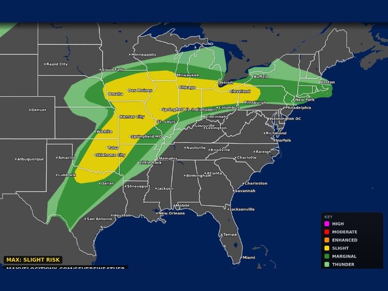
Texas to Ohio Valley Braces for Dangerous Severe Weather Wednesday With Very Large Hail, Damaging Winds, and Strong Tornadoes Possible
MIDWEST AND SOUTH — A dangerous day of severe weather is unfolding across a massive stretch of the country this Wednesday, April 15, 2026, as a powerful storm system pushes from Texas northeastward through the Ohio Valley. The Categorical Outlook issued by Max Velocity Weather places a wide corridor of states under varying levels of severe weather risk.
The greatest threats across the affected zone include very large hail, damaging winds, and a few strong tornadoes capable of impacting millions of residents from the southern Plains all the way through the northeastern United States.
Enhanced Risk Zone Covers the Core of the Threat Area
The highest risk on Wednesday’s outlook sits at the Enhanced level, covering a broad swath stretching from Texas and Oklahoma northward through Kansas City, Des Moines, Omaha, and into the Chicago and Milwaukee corridor.
Cities including Tulsa, Oklahoma City, Wichita, Kansas City, St. Louis, Springfield IL, Indianapolis, and Columbus fall within or near this zone. Residents across this corridor face the most significant probability of encountering severe storms capable of producing all three primary hazards simultaneously.
Slight Risk Extends Into the Ohio Valley and Northeast
Surrounding the Enhanced zone, a Slight Risk area extends further eastward, reaching Cleveland, Pittsburgh, Philadelphia, New York, and Boston.
This zone indicates a lower but still meaningful probability of severe storm impacts for millions of additional residents across the Ohio Valley, Mid-Atlantic, and portions of the Northeast. Even areas on the outer edges of this risk zone should remain weather-aware throughout the day.
Primary Threats Include Large Hail, Damaging Winds, and Tornadoes
Three significant hazards are associated with Wednesday’s storm system. Very large hail capable of causing property and vehicle damage is expected across the Enhanced risk zone, while damaging wind gusts pose a widespread threat across the entire corridor.
Perhaps most concerning, a few strong tornadoes are considered possible, particularly across Oklahoma, Kansas, and portions of the central Plains where atmospheric instability and wind shear are greatest heading into the afternoon hours.
Marginal Risk Covers a Wide Surrounding Area
Beyond the core threat zones, a Marginal Risk designation covers an expansive surrounding region including portions of the Deep South, the Tennessee Valley, the Great Lakes, and further into the Northeast.
Cities such as Nashville, Memphis, Atlanta, Charlotte, Detroit, Buffalo, and Richmond all fall within this broader zone. While the storm threat is lower in these areas, isolated severe weather cannot be ruled out as the system tracks eastward through the day.
Prepare Immediately and Stay Alert Throughout the Day
Given the dangerous and widespread nature of Wednesday’s severe weather outlook, forecasters are urging all residents across the affected corridor to take preparedness steps now. Have multiple ways to receive weather alerts and identify a sturdy shelter location before storms arrive.
The threat is expected to increase as the day progresses, with live coverage tracking the storm system throughout the afternoon and evening. Do not wait for a warning to be issued before taking action. Stay with NapervilleLocal.com for the latest weather updates and local forecast coverage.

I’ve lived in Naperville long enough to see how quickly our community changes — from new developments downtown to sudden shifts in our Midwest weather. Reporting on Naperville news and daily forecasts gives me the chance to keep neighbors informed about what really matters. My goal is simple: deliver clear, timely updates so you always know what’s happening in our city and what to expect from the skies above.