
Houston and Southeast Texas Endure Four More Hot and Humid Days With Highs Near 90°F Before Cool Front Arrives Saturday Evening With Rain and Relief
HOUSTON, TEXAS — Four more warm and humid days are ahead for Houston and the surrounding Southeast Texas region before a much-needed cool front sweeps into the area on Saturday evening. The front will bring a healthy chance of rain followed by significantly cooler air, offering relief from the prolonged stretch of heat that has dominated the region. Highs in the 70s are then expected to settle in and hold through the middle of next week.
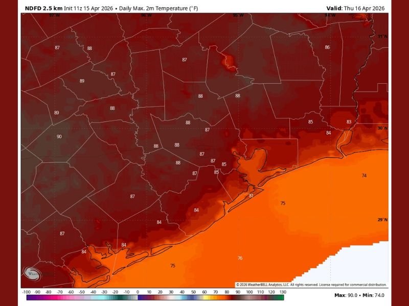
Temperatures Surge Into the Upper 80s and Near 90°F Through the Week
Temperature data valid for Thursday, April 16, 2026 shows widespread highs across Southeast Texas climbing deep into the upper 80s. Inland areas are running the hottest, with readings reaching 89°F and 90°F across western portions of the region.
The Houston metro itself is forecast to see highs in the mid to upper 80s, with values of 87°F and 88°F common across the city and surrounding suburbs. Coastal areas near Galveston and along the Gulf shoreline will be slightly cooler, with readings in the low to mid-80s due to the marine influence off the water.
Humidity Makes Conditions Feel Even Hotter
Beyond the raw temperature numbers, humidity will be a significant factor throughout the four-day warm stretch. The combination of upper 80s temperatures and elevated Gulf moisture will push heat index values well above the actual air temperature during peak afternoon hours.
Residents spending time outdoors should take precautions, stay hydrated, limit strenuous activity during the hottest parts of the afternoon, and never leave children or pets unattended in vehicles during this prolonged heat period.
Cool Front Arrives Saturday Evening With Rain Chances
The pattern shift arrives Saturday, when a cool front is expected to sweep into the Houston area likely during the evening hours. The frontal passage will bring a healthy chance of rain, offering the first meaningful precipitation opportunity the region has seen during this warm stretch.
The exact timing of the front and the associated rainfall will be refined as Saturday approaches, but residents should plan for a wet Saturday evening and remain flexible with any outdoor plans scheduled for that time.
Cooler Air Settles In Through Middle of Next Week
Behind the departing front, a dramatically different air mass will take hold across Houston and Southeast Texas heading into next week. Highs are expected to drop back into the 70s, representing a welcome and significant departure from the near-90°F readings dominating the current forecast.
The front is expected to hang around through the middle of next week, keeping conditions noticeably cooler and more comfortable for an extended period before the heat potentially returns.
Prepare for Both the Heat Now and the Front This Weekend
For the next four days, heat preparedness should remain a priority across the Houston metro and surrounding areas. As Saturday approaches, attention should shift toward monitoring the timing and rainfall potential of the incoming front.
Stay tuned to updated forecasts as the weekend system draws closer, as rainfall amounts and exact frontal timing will become clearer in the coming days. Stay with NapervilleLocal.com for the latest weather updates and local forecast coverage.

I’ve lived in Naperville long enough to see how quickly our community changes — from new developments downtown to sudden shifts in our Midwest weather. Reporting on Naperville news and daily forecasts gives me the chance to keep neighbors informed about what really matters. My goal is simple: deliver clear, timely updates so you always know what’s happening in our city and what to expect from the skies above.